You are here: Home > Network List > TA - USArray Transportable Network (new EarthScope stations) Stations List
> Station T19A Beclabito, NM, USA > Earthquake Result Viewer
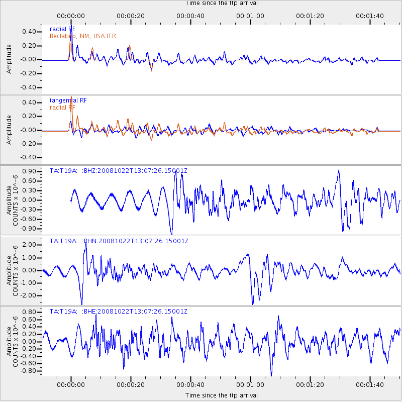
T19A Beclabito, NM, USA - Earthquake Result Viewer
*The percent match for this event was below the threshold and hence no stack was calculated.
| Earthquake location: |
Tonga Islands |
| Earthquake latitude/longitude: |
-18.4/-175.4 |
| Earthquake time(UTC): |
2008/10/22 (296) 12:55:57 GMT |
| Earthquake Depth: |
233 km |
| Earthquake Magnitude: |
5.9 MB, 6.4 MW, 6.3 MW |
| Earthquake Catalog/Contributor: |
WHDF/NEIC |
|
| Network: |
TA USArray Transportable Network (new EarthScope stations) |
| Station: |
T19A Beclabito, NM, USA |
| Lat/Lon: |
36.83 N/109.02 W |
| Elevation: |
1736 m |
|
| Distance: |
83.2 deg |
| Az: |
47.734 deg |
| Baz: |
241.128 deg |
| Ray Param: |
$rayparam |
*The percent match for this event was below the threshold and hence was not used in the summary stack. |
|
| Radial Match: |
75.826416 % |
| Radial Bump: |
357 |
| Transverse Match: |
39.197132 % |
| Transverse Bump: |
333 |
| SOD ConfigId: |
2556 |
| Insert Time: |
2010-03-06 14:28:25.735 +0000 |
| GWidth: |
2.5 |
| Max Bumps: |
400 |
| Tol: |
0.001 |
|
Signal To Noise
| Channel | StoN | STA | LTA |
| TA:T19A: :BHN:20081022T13:07:26.15001Z | 6.8290386 | 1.0958977E-6 | 1.6047613E-7 |
| TA:T19A: :BHE:20081022T13:07:26.15001Z | 1.2249297 | 2.7277528E-7 | 2.2268648E-7 |
| TA:T19A: :BHZ:20081022T13:07:26.15001Z | 2.778483 | 5.121793E-7 | 1.8433778E-7 |
| Arrivals |
| Ps | |
| PpPs | |
| PsPs/PpSs | |


