You are here: Home > Network List > TA - USArray Transportable Network (new EarthScope stations) Stations List
> Station T19A Beclabito, NM, USA > Earthquake Result Viewer
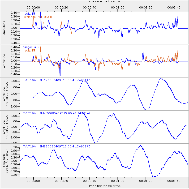
T19A Beclabito, NM, USA - Earthquake Result Viewer
*The percent match for this event was below the threshold and hence no stack was calculated.
| Earthquake location: |
Vanuatu Islands |
| Earthquake latitude/longitude: |
-20.0/168.9 |
| Earthquake time(UTC): |
2008/04/09 (100) 14:47:50 GMT |
| Earthquake Depth: |
35 km |
| Earthquake Magnitude: |
5.9 MB, 6.2 MS, 6.3 MW |
| Earthquake Catalog/Contributor: |
WHDF/NEIC |
|
| Network: |
TA USArray Transportable Network (new EarthScope stations) |
| Station: |
T19A Beclabito, NM, USA |
| Lat/Lon: |
36.83 N/109.02 W |
| Elevation: |
1736 m |
|
| Distance: |
95.7 deg |
| Az: |
53.003 deg |
| Baz: |
249.413 deg |
| Ray Param: |
$rayparam |
*The percent match for this event was below the threshold and hence was not used in the summary stack. |
|
| Radial Match: |
83.146904 % |
| Radial Bump: |
378 |
| Transverse Match: |
81.041016 % |
| Transverse Bump: |
339 |
| SOD ConfigId: |
2504 |
| Insert Time: |
2010-03-06 14:28:40.611 +0000 |
| GWidth: |
2.5 |
| Max Bumps: |
400 |
| Tol: |
0.001 |
|
Signal To Noise
| Channel | StoN | STA | LTA |
| TA:T19A: :BHN:20080409T15:00:41.249014Z | 1.5369798 | 7.1201566E-7 | 4.6325636E-7 |
| TA:T19A: :BHE:20080409T15:00:41.249014Z | 0.55630493 | 3.3853016E-7 | 6.0853347E-7 |
| TA:T19A: :BHZ:20080409T15:00:41.249014Z | 2.280047 | 1.0058933E-6 | 4.411722E-7 |
| Arrivals |
| Ps | |
| PpPs | |
| PsPs/PpSs | |


