You are here: Home > Network List > TA - USArray Transportable Network (new EarthScope stations) Stations List
> Station T19A Beclabito, NM, USA > Earthquake Result Viewer
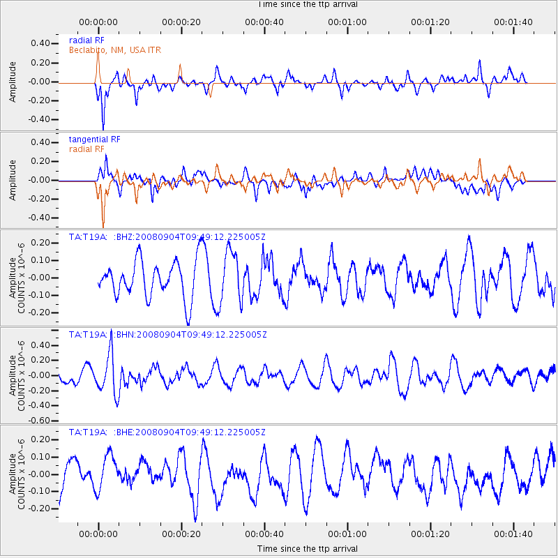
T19A Beclabito, NM, USA - Earthquake Result Viewer
*The percent match for this event was below the threshold and hence no stack was calculated.
| Earthquake location: |
Santa Cruz Islands |
| Earthquake latitude/longitude: |
-12.1/167.1 |
| Earthquake time(UTC): |
2008/09/04 (248) 09:37:03 GMT |
| Earthquake Depth: |
272 km |
| Earthquake Magnitude: |
5.5 MB, 5.7 MW, 5.6 MW |
| Earthquake Catalog/Contributor: |
WHDF/NEIC |
|
| Network: |
TA USArray Transportable Network (new EarthScope stations) |
| Station: |
T19A Beclabito, NM, USA |
| Lat/Lon: |
36.83 N/109.02 W |
| Elevation: |
1736 m |
|
| Distance: |
92.4 deg |
| Az: |
52.981 deg |
| Baz: |
256.693 deg |
| Ray Param: |
$rayparam |
*The percent match for this event was below the threshold and hence was not used in the summary stack. |
|
| Radial Match: |
61.256275 % |
| Radial Bump: |
394 |
| Transverse Match: |
53.85166 % |
| Transverse Bump: |
400 |
| SOD ConfigId: |
2504 |
| Insert Time: |
2010-03-06 14:28:51.652 +0000 |
| GWidth: |
2.5 |
| Max Bumps: |
400 |
| Tol: |
0.001 |
|
Signal To Noise
| Channel | StoN | STA | LTA |
| TA:T19A: :BHN:20080904T09:49:12.225005Z | 2.7948906 | 2.6939082E-7 | 9.63869E-8 |
| TA:T19A: :BHE:20080904T09:49:12.225005Z | 0.9786123 | 1.1940507E-7 | 1.2201468E-7 |
| TA:T19A: :BHZ:20080904T09:49:12.225005Z | 1.4003855 | 1.4673569E-7 | 1.0478235E-7 |
| Arrivals |
| Ps | |
| PpPs | |
| PsPs/PpSs | |


