You are here: Home > Network List > TA - USArray Transportable Network (new EarthScope stations) Stations List
> Station R13A O'Grain Ranch, Modena, UT, USA > Earthquake Result Viewer
R13A O'Grain Ranch, Modena, UT, USA - Earthquake Result Viewer
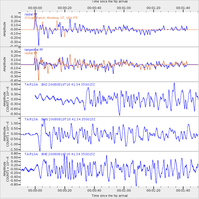
| Earthquake location: |
Tonga Islands |
| Earthquake latitude/longitude: |
-15.1/-173.5 |
| Earthquake time(UTC): |
2008/08/19 (232) 16:30:13 GMT |
| Earthquake Depth: |
8.0 km |
| Earthquake Magnitude: |
5.6 MB, 5.9 MS, 6.1 MW, 6.0 MW |
| Earthquake Catalog/Contributor: |
WHDF/NEIC |
|
| Network: |
TA USArray Transportable Network (new EarthScope stations) |
| Station: |
R13A O'Grain Ranch, Modena, UT, USA |
| Lat/Lon: |
38.18 N/113.97 W |
| Elevation: |
1969 m |
|
| Distance: |
76.9 deg |
| Az: |
44.211 deg |
| Baz: |
238.726 deg |
| Ray Param: |
0.050704084 |
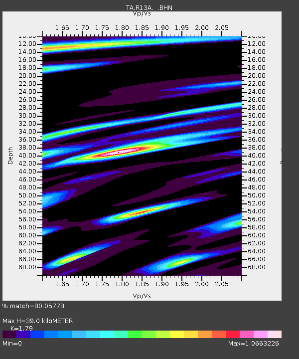
| Estimated Moho Depth: |
39.0 km |
| Estimated Crust Vp/Vs: |
1.79 |
| Assumed Crust Vp: |
6.276 km/s |
| Estimated Crust Vs: |
3.506 km/s |
| Estimated Crust Poisson's Ratio: |
0.27 |
|
| Radial Match: |
80.05778 % |
| Radial Bump: |
400 |
| Transverse Match: |
76.58029 % |
| Transverse Bump: |
400 |
| SOD ConfigId: |
2504 |
| Insert Time: |
2010-03-06 14:29:15.514 +0000 |
| GWidth: |
2.5 |
| Max Bumps: |
400 |
| Tol: |
0.001 |
|
Signal To Noise
| Channel | StoN | STA | LTA |
| TA:R13A: :BHN:20080819T16:41:34.350015Z | 11.9752 | 6.890501E-7 | 5.753976E-8 |
| TA:R13A: :BHE:20080819T16:41:34.350015Z | 2.4837155 | 2.1253092E-7 | 8.556975E-8 |
| TA:R13A: :BHZ:20080819T16:41:34.350015Z | 2.1974547 | 3.0240136E-7 | 1.3761438E-7 |
| Arrivals |
| Ps | 5.1 SECOND |
| PpPs | 17 SECOND |
| PsPs/PpSs | 22 SECOND |


