You are here: Home > Network List > TA - USArray Transportable Network (new EarthScope stations) Stations List
> Station R13A O'Grain Ranch, Modena, UT, USA > Earthquake Result Viewer
R13A O'Grain Ranch, Modena, UT, USA - Earthquake Result Viewer

| Earthquake location: |
Mariana Islands |
| Earthquake latitude/longitude: |
18.9/145.4 |
| Earthquake time(UTC): |
2007/10/31 (304) 03:30:17 GMT |
| Earthquake Depth: |
223 km |
| Earthquake Magnitude: |
6.2 MB, 7.2 MW, 7.2 MW |
| Earthquake Catalog/Contributor: |
WHDF/NEIC |
|
| Network: |
TA USArray Transportable Network (new EarthScope stations) |
| Station: |
R13A O'Grain Ranch, Modena, UT, USA |
| Lat/Lon: |
38.18 N/113.97 W |
| Elevation: |
1969 m |
|
| Distance: |
86.6 deg |
| Az: |
50.883 deg |
| Baz: |
291.237 deg |
| Ray Param: |
0.04342934 |
| Estimated Moho Depth: |
20.25 km |
| Estimated Crust Vp/Vs: |
2.10 |
| Assumed Crust Vp: |
6.276 km/s |
| Estimated Crust Vs: |
2.992 km/s |
| Estimated Crust Poisson's Ratio: |
0.35 |
|
| Radial Match: |
85.0587 % |
| Radial Bump: |
400 |
| Transverse Match: |
80.675644 % |
| Transverse Bump: |
400 |
| SOD ConfigId: |
2564 |
| Insert Time: |
2010-03-06 14:29:35.785 +0000 |
| GWidth: |
2.5 |
| Max Bumps: |
400 |
| Tol: |
0.001 |
|
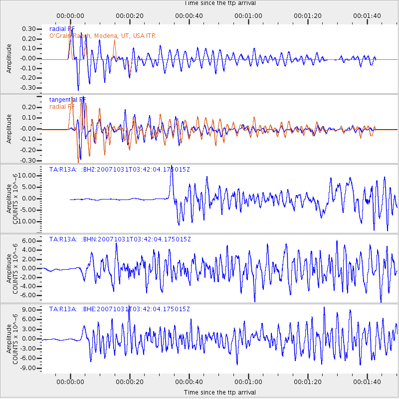
Signal To Noise
| Channel | StoN | STA | LTA |
| TA:R13A: :BHN:20071031T03:42:04.175015Z | 3.3867893 | 8.055633E-7 | 2.3785455E-7 |
| TA:R13A: :BHE:20071031T03:42:04.175015Z | 7.9883394 | 1.4477309E-6 | 1.8123053E-7 |
| TA:R13A: :BHZ:20071031T03:42:04.175015Z | 24.128082 | 5.052164E-6 | 2.0938937E-7 |
| Arrivals |
| Ps | 3.6 SECOND |
| PpPs | 9.8 SECOND |
| PsPs/PpSs | 13 SECOND |


