You are here: Home > Network List > TA - USArray Transportable Network (new EarthScope stations) Stations List
> Station R13A O'Grain Ranch, Modena, UT, USA > Earthquake Result Viewer
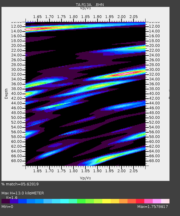
R13A O'Grain Ranch, Modena, UT, USA - Earthquake Result Viewer
| Earthquake location: |
Volcano Islands, Japan Region |
| Earthquake latitude/longitude: |
22.0/142.7 |
| Earthquake time(UTC): |
2007/09/28 (271) 13:38:59 GMT |
| Earthquake Depth: |
276 km |
| Earthquake Magnitude: |
6.7 MB, 7.4 MW, 7.4 MW |
| Earthquake Catalog/Contributor: |
WHDF/NEIC |
|
| Network: |
TA USArray Transportable Network (new EarthScope stations) |
| Station: |
R13A O'Grain Ranch, Modena, UT, USA |
| Lat/Lon: |
38.18 N/113.97 W |
| Elevation: |
1969 m |
|
| Distance: |
86.6 deg |
| Az: |
50.182 deg |
| Baz: |
295.248 deg |
| Ray Param: |
0.043290026 |
| Estimated Moho Depth: |
13.0 km |
| Estimated Crust Vp/Vs: |
1.60 |
| Assumed Crust Vp: |
6.276 km/s |
| Estimated Crust Vs: |
3.922 km/s |
| Estimated Crust Poisson's Ratio: |
0.18 |
|
| Radial Match: |
85.62819 % |
| Radial Bump: |
400 |
| Transverse Match: |
82.9716 % |
| Transverse Bump: |
400 |
| SOD ConfigId: |
2564 |
| Insert Time: |
2010-03-06 14:29:41.061 +0000 |
| GWidth: |
2.5 |
| Max Bumps: |
400 |
| Tol: |
0.001 |
|

Signal To Noise
| Channel | StoN | STA | LTA |
| TA:R13A: :BHN:20070928T13:50:40.398022Z | 16.016447 | 2.2559163E-6 | 1.4084999E-7 |
| TA:R13A: :BHE:20070928T13:50:40.398022Z | 43.870632 | 4.4348712E-6 | 1.01089746E-7 |
| TA:R13A: :BHZ:20070928T13:50:40.398022Z | 112.65595 | 1.3320738E-5 | 1.18242646E-7 |
| Arrivals |
| Ps | 1.3 SECOND |
| PpPs | 5.3 SECOND |
| PsPs/PpSs | 6.5 SECOND |


