You are here: Home > Network List > TA - USArray Transportable Network (new EarthScope stations) Stations List
> Station R13A O'Grain Ranch, Modena, UT, USA > Earthquake Result Viewer
R13A O'Grain Ranch, Modena, UT, USA - Earthquake Result Viewer
| Earthquake location: |
Southeast Of Loyalty Islands |
| Earthquake latitude/longitude: |
-21.2/169.4 |
| Earthquake time(UTC): |
2007/09/28 (271) 01:01:48 GMT |
| Earthquake Depth: |
10 km |
| Earthquake Magnitude: |
5.8 MB, 6.4 MS, 6.3 MW, 6.2 MW |
| Earthquake Catalog/Contributor: |
WHDF/NEIC |
|
| Network: |
TA USArray Transportable Network (new EarthScope stations) |
| Station: |
R13A O'Grain Ranch, Modena, UT, USA |
| Lat/Lon: |
38.18 N/113.97 W |
| Elevation: |
1969 m |
|
| Distance: |
93.0 deg |
| Az: |
50.164 deg |
| Baz: |
245.393 deg |
| Ray Param: |
0.04135329 |
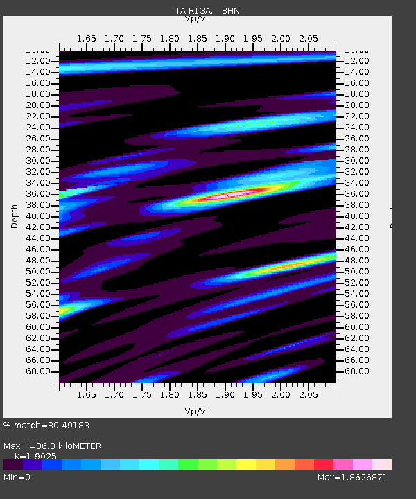
| Estimated Moho Depth: |
36.0 km |
| Estimated Crust Vp/Vs: |
1.90 |
| Assumed Crust Vp: |
6.276 km/s |
| Estimated Crust Vs: |
3.299 km/s |
| Estimated Crust Poisson's Ratio: |
0.31 |
|
| Radial Match: |
80.49183 % |
| Radial Bump: |
400 |
| Transverse Match: |
66.40262 % |
| Transverse Bump: |
400 |
| SOD ConfigId: |
2564 |
| Insert Time: |
2010-03-06 14:29:42.773 +0000 |
| GWidth: |
2.5 |
| Max Bumps: |
400 |
| Tol: |
0.001 |
|

Signal To Noise
| Channel | StoN | STA | LTA |
| TA:R13A: :BHN:20070928T01:14:30.573022Z | 0.37509984 | 6.819008E-8 | 1.8179183E-7 |
| TA:R13A: :BHE:20070928T01:14:30.573022Z | 1.7930981 | 2.007801E-7 | 1.1197385E-7 |
| TA:R13A: :BHZ:20070928T01:14:30.573022Z | 4.158098 | 4.1752577E-7 | 1.0041267E-7 |
| Arrivals |
| Ps | 5.3 SECOND |
| PpPs | 16 SECOND |
| PsPs/PpSs | 22 SECOND |


