You are here: Home > Network List > CI - Caltech Regional Seismic Network Stations List
> Station MPM Manuel Prospect Mine, California, USA > Earthquake Result Viewer
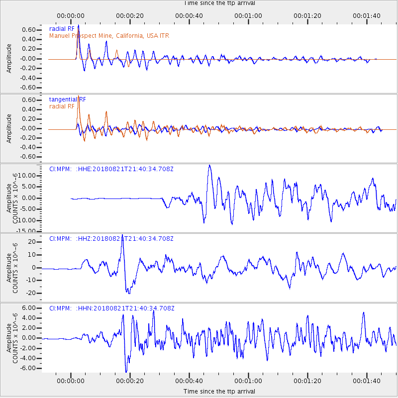
MPM Manuel Prospect Mine, California, USA - Earthquake Result Viewer
*The percent match for this event was below the threshold and hence no stack was calculated.
| Earthquake location: |
Near Coast Of Venezuela |
| Earthquake latitude/longitude: |
10.9/-62.9 |
| Earthquake time(UTC): |
2018/08/21 (233) 21:31:46 GMT |
| Earthquake Depth: |
154 km |
| Earthquake Magnitude: |
7.3 Mww |
| Earthquake Catalog/Contributor: |
NEIC PDE/us |
|
| Network: |
CI Caltech Regional Seismic Network |
| Station: |
MPM Manuel Prospect Mine, California, USA |
| Lat/Lon: |
36.06 N/117.49 W |
| Elevation: |
185 m |
|
| Distance: |
55.2 deg |
| Az: |
306.448 deg |
| Baz: |
102.791 deg |
| Ray Param: |
$rayparam |
*The percent match for this event was below the threshold and hence was not used in the summary stack. |
|
| Radial Match: |
94.67062 % |
| Radial Bump: |
400 |
| Transverse Match: |
81.18807 % |
| Transverse Bump: |
400 |
| SOD ConfigId: |
13570011 |
| Insert Time: |
2019-04-30 22:24:43.852 +0000 |
| GWidth: |
2.5 |
| Max Bumps: |
400 |
| Tol: |
0.001 |
|
Signal To Noise
| Channel | StoN | STA | LTA |
| CI:MPM: :HHZ:20180821T21:40:34.708Z | 22.709145 | 2.4900714E-6 | 1.0965061E-7 |
| CI:MPM: :HHN:20180821T21:40:34.708Z | 8.770448 | 3.6501268E-7 | 4.1618478E-8 |
| CI:MPM: :HHE:20180821T21:40:34.708Z | 9.452429 | 1.1773612E-6 | 1.245565E-7 |
| Arrivals |
| Ps | |
| PpPs | |
| PsPs/PpSs | |


