You are here: Home > Network List > TA - USArray Transportable Network (new EarthScope stations) Stations List
> Station R13A O'Grain Ranch, Modena, UT, USA > Earthquake Result Viewer
R13A O'Grain Ranch, Modena, UT, USA - Earthquake Result Viewer
| Earthquake location: |
Andreanof Islands, Aleutian Is. |
| Earthquake latitude/longitude: |
50.3/-177.5 |
| Earthquake time(UTC): |
2007/08/15 (227) 20:22:11 GMT |
| Earthquake Depth: |
9.0 km |
| Earthquake Magnitude: |
6.3 MB, 6.2 MS, 6.4 MW, 5.9 ML |
| Earthquake Catalog/Contributor: |
WHDF/NEIC |
|
| Network: |
TA USArray Transportable Network (new EarthScope stations) |
| Station: |
R13A O'Grain Ranch, Modena, UT, USA |
| Lat/Lon: |
38.18 N/113.97 W |
| Elevation: |
1969 m |
|
| Distance: |
45.8 deg |
| Az: |
79.922 deg |
| Baz: |
306.791 deg |
| Ray Param: |
0.071046464 |
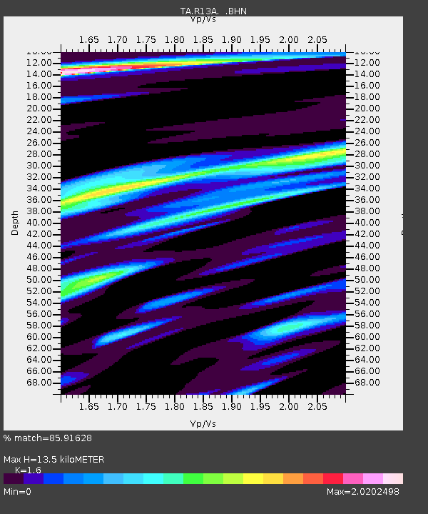
| Estimated Moho Depth: |
13.5 km |
| Estimated Crust Vp/Vs: |
1.60 |
| Assumed Crust Vp: |
6.276 km/s |
| Estimated Crust Vs: |
3.922 km/s |
| Estimated Crust Poisson's Ratio: |
0.18 |
|
| Radial Match: |
85.91628 % |
| Radial Bump: |
400 |
| Transverse Match: |
76.68812 % |
| Transverse Bump: |
400 |
| SOD ConfigId: |
2564 |
| Insert Time: |
2010-03-06 14:29:55.369 +0000 |
| GWidth: |
2.5 |
| Max Bumps: |
400 |
| Tol: |
0.001 |
|
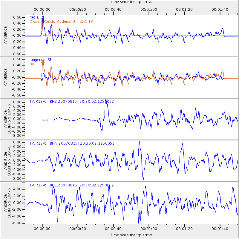
Signal To Noise
| Channel | StoN | STA | LTA |
| TA:R13A: :BHN:20070815T20:30:02.125005Z | 1.2759918 | 8.9455546E-7 | 7.0106677E-7 |
| TA:R13A: :BHE:20070815T20:30:02.125005Z | 2.1456993 | 1.1001094E-6 | 5.127044E-7 |
| TA:R13A: :BHZ:20070815T20:30:02.125005Z | 5.2434444 | 2.2157224E-6 | 4.2257E-7 |
| Arrivals |
| Ps | 1.4 SECOND |
| PpPs | 5.2 SECOND |
| PsPs/PpSs | 6.6 SECOND |


