You are here: Home > Network List > CN - Canadian National Seismograph Network Stations List
> Station INK INUVIK, NT > Earthquake Result Viewer
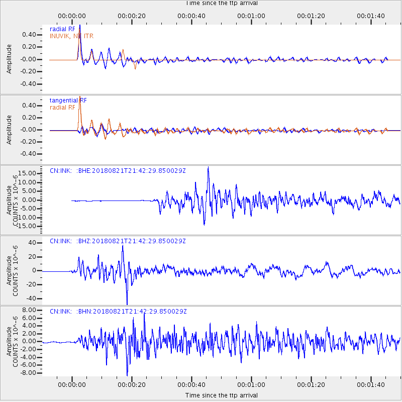
INK INUVIK, NT - Earthquake Result Viewer
*The percent match for this event was below the threshold and hence no stack was calculated.
| Earthquake location: |
Near Coast Of Venezuela |
| Earthquake latitude/longitude: |
10.9/-62.9 |
| Earthquake time(UTC): |
2018/08/21 (233) 21:31:46 GMT |
| Earthquake Depth: |
154 km |
| Earthquake Magnitude: |
7.3 Mww |
| Earthquake Catalog/Contributor: |
NEIC PDE/us |
|
| Network: |
CN Canadian National Seismograph Network |
| Station: |
INK INUVIK, NT |
| Lat/Lon: |
68.31 N/133.53 W |
| Elevation: |
44 m |
|
| Distance: |
72.9 deg |
| Az: |
338.464 deg |
| Baz: |
104.094 deg |
| Ray Param: |
$rayparam |
*The percent match for this event was below the threshold and hence was not used in the summary stack. |
|
| Radial Match: |
97.04582 % |
| Radial Bump: |
355 |
| Transverse Match: |
89.9999 % |
| Transverse Bump: |
400 |
| SOD ConfigId: |
13570011 |
| Insert Time: |
2019-04-30 22:25:24.241 +0000 |
| GWidth: |
2.5 |
| Max Bumps: |
400 |
| Tol: |
0.001 |
|
Signal To Noise
| Channel | StoN | STA | LTA |
| CN:INK: :BHZ:20180821T21:42:29.850029Z | 49.159153 | 7.437265E-6 | 1.5128953E-7 |
| CN:INK: :BHN:20180821T21:42:29.850029Z | 8.3575115 | 6.224108E-7 | 7.447323E-8 |
| CN:INK: :BHE:20180821T21:42:29.850029Z | 31.87254 | 2.6852515E-6 | 8.4249685E-8 |
| Arrivals |
| Ps | |
| PpPs | |
| PsPs/PpSs | |


