You are here: Home > Network List > TA - USArray Transportable Network (new EarthScope stations) Stations List
> Station F21K Alatna River, AK, USA > Earthquake Result Viewer
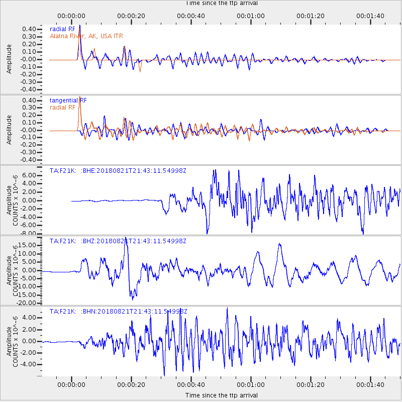
F21K Alatna River, AK, USA - Earthquake Result Viewer
*The percent match for this event was below the threshold and hence no stack was calculated.
| Earthquake location: |
Near Coast Of Venezuela |
| Earthquake latitude/longitude: |
10.9/-62.9 |
| Earthquake time(UTC): |
2018/08/21 (233) 21:31:46 GMT |
| Earthquake Depth: |
154 km |
| Earthquake Magnitude: |
7.3 Mww |
| Earthquake Catalog/Contributor: |
NEIC PDE/us |
|
| Network: |
TA USArray Transportable Network (new EarthScope stations) |
| Station: |
F21K Alatna River, AK, USA |
| Lat/Lon: |
67.22 N/153.48 W |
| Elevation: |
597 m |
|
| Distance: |
80.3 deg |
| Az: |
336.735 deg |
| Baz: |
85.209 deg |
| Ray Param: |
$rayparam |
*The percent match for this event was below the threshold and hence was not used in the summary stack. |
|
| Radial Match: |
89.24896 % |
| Radial Bump: |
400 |
| Transverse Match: |
72.91617 % |
| Transverse Bump: |
400 |
| SOD ConfigId: |
13570011 |
| Insert Time: |
2019-04-30 22:32:27.031 +0000 |
| GWidth: |
2.5 |
| Max Bumps: |
400 |
| Tol: |
0.001 |
|
Signal To Noise
| Channel | StoN | STA | LTA |
| TA:F21K: :BHZ:20180821T21:43:11.54998Z | 27.078476 | 3.7186828E-6 | 1.3732985E-7 |
| TA:F21K: :BHN:20180821T21:43:11.54998Z | 5.7316327 | 3.9206958E-7 | 6.840452E-8 |
| TA:F21K: :BHE:20180821T21:43:11.54998Z | 15.946567 | 1.3847268E-6 | 8.683542E-8 |
| Arrivals |
| Ps | |
| PpPs | |
| PsPs/PpSs | |


