You are here: Home > Network List > TA - USArray Transportable Network (new EarthScope stations) Stations List
> Station F26K Sheenjek River, AK, USA > Earthquake Result Viewer
F26K Sheenjek River, AK, USA - Earthquake Result Viewer
*The percent match for this event was below the threshold and hence no stack was calculated.
| Earthquake location: |
Near Coast Of Venezuela |
| Earthquake latitude/longitude: |
10.9/-62.9 |
| Earthquake time(UTC): |
2018/08/21 (233) 21:31:46 GMT |
| Earthquake Depth: |
154 km |
| Earthquake Magnitude: |
7.3 Mww |
| Earthquake Catalog/Contributor: |
NEIC PDE/us |
|
| Network: |
TA USArray Transportable Network (new EarthScope stations) |
| Station: |
F26K Sheenjek River, AK, USA |
| Lat/Lon: |
67.69 N/144.15 W |
| Elevation: |
683 m |
|
| Distance: |
76.7 deg |
| Az: |
337.189 deg |
| Baz: |
93.918 deg |
| Ray Param: |
$rayparam |
*The percent match for this event was below the threshold and hence was not used in the summary stack. |
|
| Radial Match: |
94.959854 % |
| Radial Bump: |
400 |
| Transverse Match: |
87.16368 % |
| Transverse Bump: |
400 |
| SOD ConfigId: |
13570011 |
| Insert Time: |
2019-04-30 22:32:32.265 +0000 |
| GWidth: |
2.5 |
| Max Bumps: |
400 |
| Tol: |
0.001 |
|
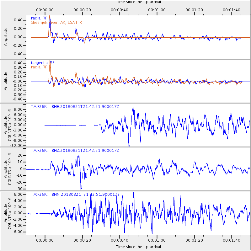
Signal To Noise
| Channel | StoN | STA | LTA |
| TA:F26K: :BHZ:20180821T21:42:51.900017Z | 29.96683 | 4.6740765E-6 | 1.5597502E-7 |
| TA:F26K: :BHN:20180821T21:42:51.900017Z | 2.7763822 | 2.1116834E-7 | 7.605881E-8 |
| TA:F26K: :BHE:20180821T21:42:51.900017Z | 18.535187 | 1.8251951E-6 | 9.847191E-8 |
| Arrivals |
| Ps | |
| PpPs | |
| PsPs/PpSs | |


