You are here: Home > Network List > TA - USArray Transportable Network (new EarthScope stations) Stations List
> Station L20K Farewell, AK, USA > Earthquake Result Viewer
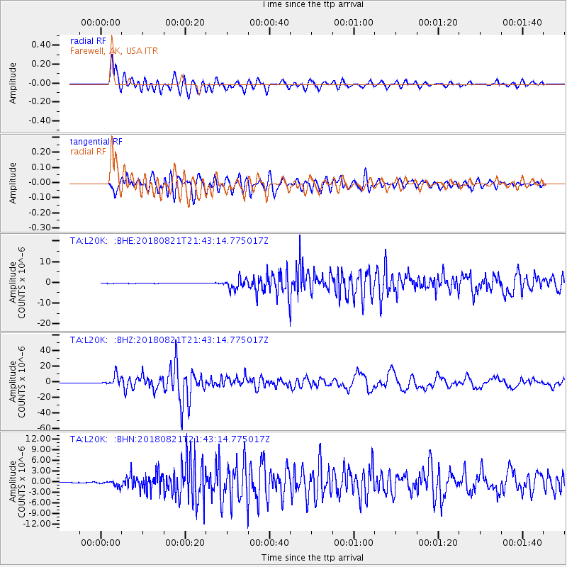
L20K Farewell, AK, USA - Earthquake Result Viewer
*The percent match for this event was below the threshold and hence no stack was calculated.
| Earthquake location: |
Near Coast Of Venezuela |
| Earthquake latitude/longitude: |
10.9/-62.9 |
| Earthquake time(UTC): |
2018/08/21 (233) 21:31:46 GMT |
| Earthquake Depth: |
154 km |
| Earthquake Magnitude: |
7.3 Mww |
| Earthquake Catalog/Contributor: |
NEIC PDE/us |
|
| Network: |
TA USArray Transportable Network (new EarthScope stations) |
| Station: |
L20K Farewell, AK, USA |
| Lat/Lon: |
62.48 N/153.88 W |
| Elevation: |
673 m |
|
| Distance: |
80.9 deg |
| Az: |
331.944 deg |
| Baz: |
84.068 deg |
| Ray Param: |
$rayparam |
*The percent match for this event was below the threshold and hence was not used in the summary stack. |
|
| Radial Match: |
93.20146 % |
| Radial Bump: |
400 |
| Transverse Match: |
91.42755 % |
| Transverse Bump: |
400 |
| SOD ConfigId: |
13570011 |
| Insert Time: |
2019-04-30 22:33:20.687 +0000 |
| GWidth: |
2.5 |
| Max Bumps: |
400 |
| Tol: |
0.001 |
|
Signal To Noise
| Channel | StoN | STA | LTA |
| TA:L20K: :BHZ:20180821T21:43:14.775017Z | 52.741467 | 6.471023E-6 | 1.2269327E-7 |
| TA:L20K: :BHN:20180821T21:43:14.775017Z | 6.52627 | 7.705015E-7 | 1.1806154E-7 |
| TA:L20K: :BHE:20180821T21:43:14.775017Z | 19.679764 | 1.8856346E-6 | 9.581591E-8 |
| Arrivals |
| Ps | |
| PpPs | |
| PsPs/PpSs | |


