You are here: Home > Network List > UW - Pacific Northwest Regional Seismic Network Stations List
> Station LTY Liberty (broad-band) > Earthquake Result Viewer
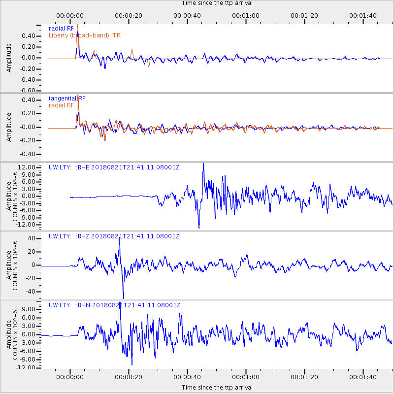
LTY Liberty (broad-band) - Earthquake Result Viewer
*The percent match for this event was below the threshold and hence no stack was calculated.
| Earthquake location: |
Near Coast Of Venezuela |
| Earthquake latitude/longitude: |
10.9/-62.9 |
| Earthquake time(UTC): |
2018/08/21 (233) 21:31:46 GMT |
| Earthquake Depth: |
154 km |
| Earthquake Magnitude: |
7.3 Mww |
| Earthquake Catalog/Contributor: |
NEIC PDE/us |
|
| Network: |
UW Pacific Northwest Regional Seismic Network |
| Station: |
LTY Liberty (broad-band) |
| Lat/Lon: |
47.26 N/120.66 W |
| Elevation: |
970 m |
|
| Distance: |
60.4 deg |
| Az: |
318.493 deg |
| Baz: |
107.119 deg |
| Ray Param: |
$rayparam |
*The percent match for this event was below the threshold and hence was not used in the summary stack. |
|
| Radial Match: |
94.431206 % |
| Radial Bump: |
400 |
| Transverse Match: |
90.72462 % |
| Transverse Bump: |
400 |
| SOD ConfigId: |
13570011 |
| Insert Time: |
2019-04-30 22:36:11.425 +0000 |
| GWidth: |
2.5 |
| Max Bumps: |
400 |
| Tol: |
0.001 |
|
Signal To Noise
| Channel | StoN | STA | LTA |
| UW:LTY: :BHZ:20180821T21:41:11.08001Z | 33.614754 | 5.3634813E-6 | 1.5955736E-7 |
| UW:LTY: :BHN:20180821T21:41:11.08001Z | 12.248731 | 1.5588523E-6 | 1.2726643E-7 |
| UW:LTY: :BHE:20180821T21:41:11.08001Z | 6.529322 | 1.7306606E-6 | 2.6505978E-7 |
| Arrivals |
| Ps | |
| PpPs | |
| PsPs/PpSs | |


