You are here: Home > Network List > TA - USArray Transportable Network (new EarthScope stations) Stations List
> Station R18A Canyonlands National Park, Moab, UT, USA > Earthquake Result Viewer
R18A Canyonlands National Park, Moab, UT, USA - Earthquake Result Viewer
| Earthquake location: |
Central East Pacific Rise |
| Earthquake latitude/longitude: |
-4.6/-106.0 |
| Earthquake time(UTC): |
2008/09/18 (262) 01:41:02 GMT |
| Earthquake Depth: |
10 km |
| Earthquake Magnitude: |
5.5 MB, 5.7 MS, 6.0 MW, 6.0 MW |
| Earthquake Catalog/Contributor: |
WHDF/NEIC |
|
| Network: |
TA USArray Transportable Network (new EarthScope stations) |
| Station: |
R18A Canyonlands National Park, Moab, UT, USA |
| Lat/Lon: |
38.39 N/109.89 W |
| Elevation: |
1828 m |
|
| Distance: |
42.9 deg |
| Az: |
355.501 deg |
| Baz: |
174.29 deg |
| Ray Param: |
0.07291001 |
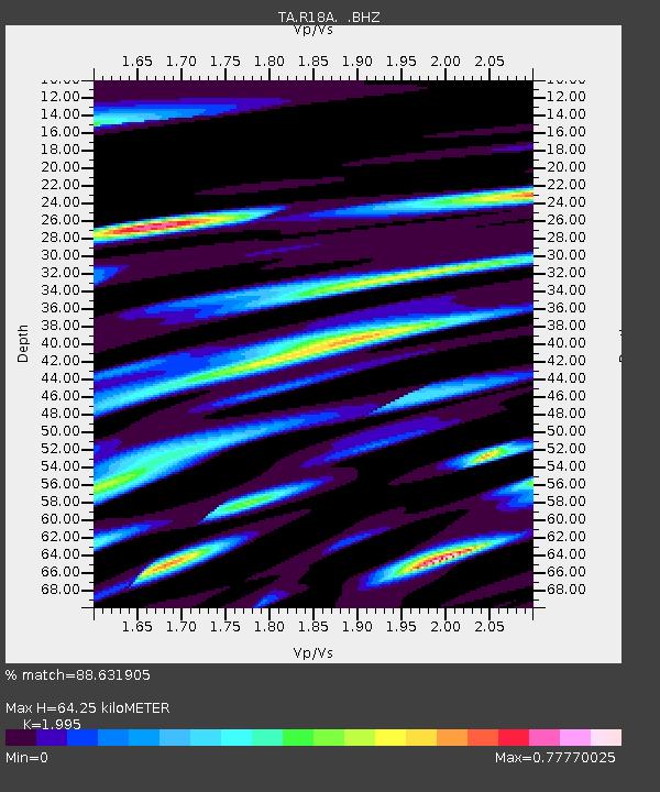
| Estimated Moho Depth: |
64.25 km |
| Estimated Crust Vp/Vs: |
2.00 |
| Assumed Crust Vp: |
6.291 km/s |
| Estimated Crust Vs: |
3.153 km/s |
| Estimated Crust Poisson's Ratio: |
0.33 |
|
| Radial Match: |
88.631905 % |
| Radial Bump: |
400 |
| Transverse Match: |
67.37635 % |
| Transverse Bump: |
400 |
| SOD ConfigId: |
2560 |
| Insert Time: |
2010-03-06 14:32:50.725 +0000 |
| GWidth: |
2.5 |
| Max Bumps: |
400 |
| Tol: |
0.001 |
|

Signal To Noise
| Channel | StoN | STA | LTA |
| TA:R18A: :BHZ:20080918T01:48:30.375004Z | 5.8627 | 3.5856323E-7 | 6.116009E-8 |
| TA:R18A: :BHN:20080918T01:48:30.375004Z | 3.6025727 | 2.0894912E-7 | 5.799997E-8 |
| TA:R18A: :BHE:20080918T01:48:30.375004Z | 1.0027664 | 6.881302E-8 | 6.862319E-8 |
| Arrivals |
| Ps | 11 SECOND |
| PpPs | 29 SECOND |
| PsPs/PpSs | 40 SECOND |


