You are here: Home > Network List > TA - USArray Transportable Network (new EarthScope stations) Stations List
> Station R18A Canyonlands National Park, Moab, UT, USA > Earthquake Result Viewer
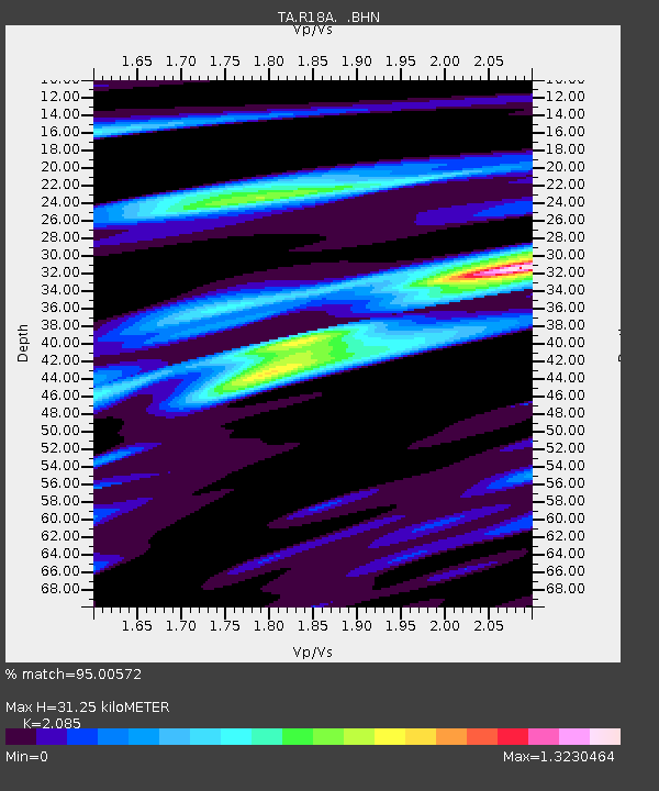
R18A Canyonlands National Park, Moab, UT, USA - Earthquake Result Viewer
| Earthquake location: |
Windward Islands |
| Earthquake latitude/longitude: |
15.0/-61.3 |
| Earthquake time(UTC): |
2007/11/29 (333) 19:00:19 GMT |
| Earthquake Depth: |
148 km |
| Earthquake Magnitude: |
6.9 MB, 7.4 MW, 7.4 MW |
| Earthquake Catalog/Contributor: |
WHDF/NEIC |
|
| Network: |
TA USArray Transportable Network (new EarthScope stations) |
| Station: |
R18A Canyonlands National Park, Moab, UT, USA |
| Lat/Lon: |
38.39 N/109.89 W |
| Elevation: |
1828 m |
|
| Distance: |
48.6 deg |
| Az: |
308.213 deg |
| Baz: |
104.918 deg |
| Ray Param: |
0.068694584 |
| Estimated Moho Depth: |
31.25 km |
| Estimated Crust Vp/Vs: |
2.09 |
| Assumed Crust Vp: |
6.291 km/s |
| Estimated Crust Vs: |
3.017 km/s |
| Estimated Crust Poisson's Ratio: |
0.35 |
|
| Radial Match: |
95.00572 % |
| Radial Bump: |
400 |
| Transverse Match: |
85.25436 % |
| Transverse Bump: |
400 |
| SOD ConfigId: |
2564 |
| Insert Time: |
2010-03-06 14:33:06.996 +0000 |
| GWidth: |
2.5 |
| Max Bumps: |
400 |
| Tol: |
0.001 |
|

Signal To Noise
| Channel | StoN | STA | LTA |
| TA:R18A: :BHN:20071129T19:08:18.074011Z | 15.084349 | 2.3502735E-6 | 1.5580873E-7 |
| TA:R18A: :BHE:20071129T19:08:18.074011Z | 26.018856 | 6.638422E-6 | 2.551389E-7 |
| TA:R18A: :BHZ:20071129T19:08:18.074011Z | 40.563618 | 1.1680014E-5 | 2.879431E-7 |
| Arrivals |
| Ps | 5.7 SECOND |
| PpPs | 15 SECOND |
| PsPs/PpSs | 20 SECOND |


