You are here: Home > Network List > TA - USArray Transportable Network (new EarthScope stations) Stations List
> Station R18A Canyonlands National Park, Moab, UT, USA > Earthquake Result Viewer
R18A Canyonlands National Park, Moab, UT, USA - Earthquake Result Viewer

| Earthquake location: |
Jujuy Province, Argentina |
| Earthquake latitude/longitude: |
-22.2/-65.8 |
| Earthquake time(UTC): |
2007/07/21 (202) 15:34:52 GMT |
| Earthquake Depth: |
290 km |
| Earthquake Magnitude: |
5.8 MB, 6.4 MW, 6.3 MW |
| Earthquake Catalog/Contributor: |
WHDF/NEIC |
|
| Network: |
TA USArray Transportable Network (new EarthScope stations) |
| Station: |
R18A Canyonlands National Park, Moab, UT, USA |
| Lat/Lon: |
38.39 N/109.89 W |
| Elevation: |
1828 m |
|
| Distance: |
73.1 deg |
| Az: |
325.121 deg |
| Baz: |
137.577 deg |
| Ray Param: |
0.05242211 |
| Estimated Moho Depth: |
38.75 km |
| Estimated Crust Vp/Vs: |
1.90 |
| Assumed Crust Vp: |
6.291 km/s |
| Estimated Crust Vs: |
3.302 km/s |
| Estimated Crust Poisson's Ratio: |
0.31 |
|
| Radial Match: |
93.70056 % |
| Radial Bump: |
327 |
| Transverse Match: |
85.451416 % |
| Transverse Bump: |
400 |
| SOD ConfigId: |
2564 |
| Insert Time: |
2010-03-06 14:33:36.001 +0000 |
| GWidth: |
2.5 |
| Max Bumps: |
400 |
| Tol: |
0.001 |
|
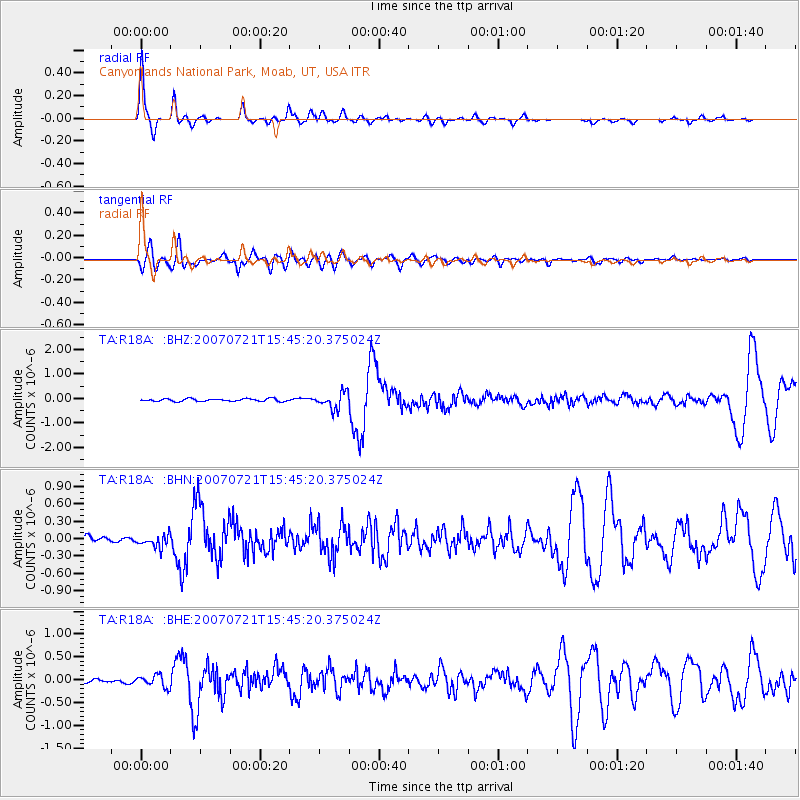
Signal To Noise
| Channel | StoN | STA | LTA |
| TA:R18A: :BHN:20070721T15:45:20.375024Z | 2.2894447 | 1.08074694E-7 | 4.720564E-8 |
| TA:R18A: :BHE:20070721T15:45:20.375024Z | 4.2857795 | 1.2886812E-7 | 3.0068772E-8 |
| TA:R18A: :BHZ:20070721T15:45:20.375024Z | 6.2598243 | 3.276359E-7 | 5.2339473E-8 |
| Arrivals |
| Ps | 5.7 SECOND |
| PpPs | 17 SECOND |
| PsPs/PpSs | 23 SECOND |


