You are here: Home > Network List > TA - USArray Transportable Network (new EarthScope stations) Stations List
> Station R18A Canyonlands National Park, Moab, UT, USA > Earthquake Result Viewer
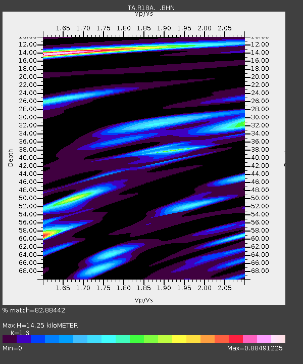
R18A Canyonlands National Park, Moab, UT, USA - Earthquake Result Viewer
| Earthquake location: |
South Of Fiji Islands |
| Earthquake latitude/longitude: |
-26.3/-177.7 |
| Earthquake time(UTC): |
2007/07/18 (199) 00:07:35 GMT |
| Earthquake Depth: |
10 km |
| Earthquake Magnitude: |
5.8 MB, 5.9 MS, 6.1 MW, 6.0 MW |
| Earthquake Catalog/Contributor: |
WHDF/NEIC |
|
| Network: |
TA USArray Transportable Network (new EarthScope stations) |
| Station: |
R18A Canyonlands National Park, Moab, UT, USA |
| Lat/Lon: |
38.39 N/109.89 W |
| Elevation: |
1828 m |
|
| Distance: |
90.4 deg |
| Az: |
46.707 deg |
| Baz: |
236.246 deg |
| Ray Param: |
0.041678417 |
| Estimated Moho Depth: |
14.25 km |
| Estimated Crust Vp/Vs: |
1.60 |
| Assumed Crust Vp: |
6.291 km/s |
| Estimated Crust Vs: |
3.932 km/s |
| Estimated Crust Poisson's Ratio: |
0.18 |
|
| Radial Match: |
82.88442 % |
| Radial Bump: |
400 |
| Transverse Match: |
71.076965 % |
| Transverse Bump: |
400 |
| SOD ConfigId: |
2564 |
| Insert Time: |
2010-03-06 14:33:37.869 +0000 |
| GWidth: |
2.5 |
| Max Bumps: |
400 |
| Tol: |
0.001 |
|

Signal To Noise
| Channel | StoN | STA | LTA |
| TA:R18A: :BHN:20070718T00:20:05.175027Z | 1.3632271 | 6.515728E-8 | 4.7796355E-8 |
| TA:R18A: :BHE:20070718T00:20:05.175027Z | 0.7768557 | 3.6712212E-8 | 4.725744E-8 |
| TA:R18A: :BHZ:20070718T00:20:05.175027Z | 1.7338446 | 9.7200655E-8 | 5.6060763E-8 |
| Arrivals |
| Ps | 1.4 SECOND |
| PpPs | 5.8 SECOND |
| PsPs/PpSs | 7.2 SECOND |


