You are here: Home > Network List > CI - Caltech Regional Seismic Network Stations List
> Station SWS Sam W. Stewart, Westmorland, CA, USA > Earthquake Result Viewer
SWS Sam W. Stewart, Westmorland, CA, USA - Earthquake Result Viewer
| Earthquake location: |
Vanuatu Islands |
| Earthquake latitude/longitude: |
-16.0/168.2 |
| Earthquake time(UTC): |
2018/08/21 (233) 22:32:27 GMT |
| Earthquake Depth: |
13 km |
| Earthquake Magnitude: |
6.5 Mww |
| Earthquake Catalog/Contributor: |
NEIC PDE/us |
|
| Network: |
CI Caltech Regional Seismic Network |
| Station: |
SWS Sam W. Stewart, Westmorland, CA, USA |
| Lat/Lon: |
32.94 N/115.80 W |
| Elevation: |
140 m |
|
| Distance: |
87.3 deg |
| Az: |
54.784 deg |
| Baz: |
249.119 deg |
| Ray Param: |
0.04339121 |
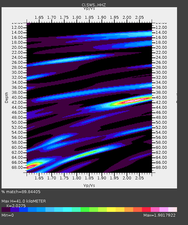
| Estimated Moho Depth: |
41.0 km |
| Estimated Crust Vp/Vs: |
2.03 |
| Assumed Crust Vp: |
6.155 km/s |
| Estimated Crust Vs: |
3.036 km/s |
| Estimated Crust Poisson's Ratio: |
0.34 |
|
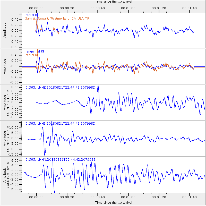
| Radial Match: |
89.84405 % |
| Radial Bump: |
304 |
| Transverse Match: |
78.31203 % |
| Transverse Bump: |
400 |
| SOD ConfigId: |
13570011 |
| Insert Time: |
2019-04-30 22:41:54.202 +0000 |
| GWidth: |
2.5 |
| Max Bumps: |
400 |
| Tol: |
0.001 |
|
Signal To Noise
| Channel | StoN | STA | LTA |
| CI:SWS: :HHZ:20180821T22:44:42.207998Z | 14.091219 | 4.028818E-6 | 2.859098E-7 |
| CI:SWS: :HHN:20180821T22:44:42.207998Z | 2.1815565 | 1.4800386E-6 | 6.7843234E-7 |
| CI:SWS: :HHE:20180821T22:44:42.207998Z | 2.9471345 | 1.7416974E-6 | 5.909799E-7 |
| Arrivals |
| Ps | 7.0 SECOND |
| PpPs | 20 SECOND |
| PsPs/PpSs | 27 SECOND |


