You are here: Home > Network List > TA - USArray Transportable Network (new EarthScope stations) Stations List
> Station R18A Canyonlands National Park, Moab, UT, USA > Earthquake Result Viewer
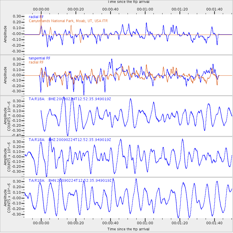
R18A Canyonlands National Park, Moab, UT, USA - Earthquake Result Viewer
*The percent match for this event was below the threshold and hence no stack was calculated.
| Earthquake location: |
Southeast Of Loyalty Islands |
| Earthquake latitude/longitude: |
-23.2/170.6 |
| Earthquake time(UTC): |
2009/02/24 (055) 12:39:41 GMT |
| Earthquake Depth: |
32 km |
| Earthquake Magnitude: |
5.6 MB, 5.7 MW, 5.6 MW |
| Earthquake Catalog/Contributor: |
WHDF/NEIC |
|
| Network: |
TA USArray Transportable Network (new EarthScope stations) |
| Station: |
R18A Canyonlands National Park, Moab, UT, USA |
| Lat/Lon: |
38.39 N/109.89 W |
| Elevation: |
1828 m |
|
| Distance: |
96.4 deg |
| Az: |
51.043 deg |
| Baz: |
245.584 deg |
| Ray Param: |
$rayparam |
*The percent match for this event was below the threshold and hence was not used in the summary stack. |
|
| Radial Match: |
35.82103 % |
| Radial Bump: |
393 |
| Transverse Match: |
50.976032 % |
| Transverse Bump: |
400 |
| SOD ConfigId: |
2658 |
| Insert Time: |
2010-03-06 14:35:08.150 +0000 |
| GWidth: |
2.5 |
| Max Bumps: |
400 |
| Tol: |
0.001 |
|
Signal To Noise
| Channel | StoN | STA | LTA |
| TA:R18A: :BHZ:20090224T12:52:35.949019Z | 1.859255 | 2.2640445E-7 | 1.217716E-7 |
| TA:R18A: :BHN:20090224T12:52:35.949019Z | 2.3521373 | 2.069592E-7 | 8.7987715E-8 |
| TA:R18A: :BHE:20090224T12:52:35.949019Z | 0.52310497 | 1.062134E-7 | 2.0304415E-7 |
| Arrivals |
| Ps | |
| PpPs | |
| PsPs/PpSs | |


