You are here: Home > Network List > TA - USArray Transportable Network (new EarthScope stations) Stations List
> Station L15K Ungalak Mountain, AK, USA > Earthquake Result Viewer
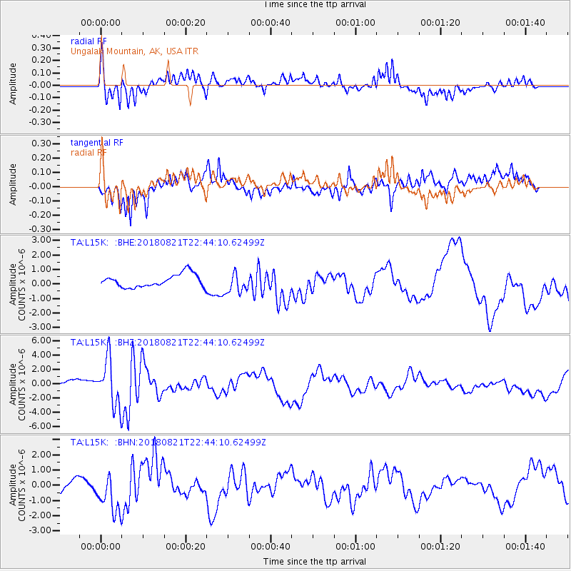
L15K Ungalak Mountain, AK, USA - Earthquake Result Viewer
*The percent match for this event was below the threshold and hence no stack was calculated.
| Earthquake location: |
Vanuatu Islands |
| Earthquake latitude/longitude: |
-16.0/168.2 |
| Earthquake time(UTC): |
2018/08/21 (233) 22:32:27 GMT |
| Earthquake Depth: |
13 km |
| Earthquake Magnitude: |
6.5 Mww |
| Earthquake Catalog/Contributor: |
NEIC PDE/us |
|
| Network: |
TA USArray Transportable Network (new EarthScope stations) |
| Station: |
L15K Ungalak Mountain, AK, USA |
| Lat/Lon: |
61.68 N/161.49 W |
| Elevation: |
219 m |
|
| Distance: |
81.1 deg |
| Az: |
14.121 deg |
| Baz: |
209.471 deg |
| Ray Param: |
$rayparam |
*The percent match for this event was below the threshold and hence was not used in the summary stack. |
|
| Radial Match: |
74.995926 % |
| Radial Bump: |
400 |
| Transverse Match: |
55.150124 % |
| Transverse Bump: |
400 |
| SOD ConfigId: |
13570011 |
| Insert Time: |
2019-04-30 22:45:21.238 +0000 |
| GWidth: |
2.5 |
| Max Bumps: |
400 |
| Tol: |
0.001 |
|
Signal To Noise
| Channel | StoN | STA | LTA |
| TA:L15K: :BHZ:20180821T22:44:10.62499Z | 5.660773 | 3.3895983E-6 | 5.987872E-7 |
| TA:L15K: :BHN:20180821T22:44:10.62499Z | 1.2293465 | 1.5733281E-6 | 1.2798084E-6 |
| TA:L15K: :BHE:20180821T22:44:10.62499Z | 1.63035 | 7.1613897E-7 | 4.3925476E-7 |
| Arrivals |
| Ps | |
| PpPs | |
| PsPs/PpSs | |


