You are here: Home > Network List > TA - USArray Transportable Network (new EarthScope stations) Stations List
> Station M11K Mekoryuk, AK, USA > Earthquake Result Viewer
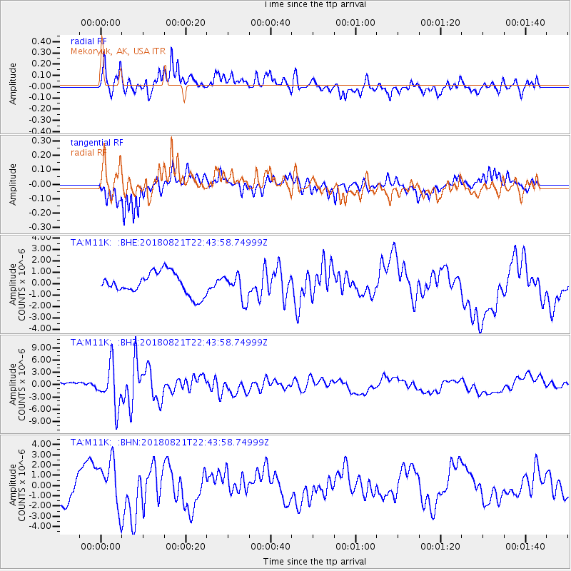
M11K Mekoryuk, AK, USA - Earthquake Result Viewer
*The percent match for this event was below the threshold and hence no stack was calculated.
| Earthquake location: |
Vanuatu Islands |
| Earthquake latitude/longitude: |
-16.0/168.2 |
| Earthquake time(UTC): |
2018/08/21 (233) 22:32:27 GMT |
| Earthquake Depth: |
13 km |
| Earthquake Magnitude: |
6.5 Mww |
| Earthquake Catalog/Contributor: |
NEIC PDE/us |
|
| Network: |
TA USArray Transportable Network (new EarthScope stations) |
| Station: |
M11K Mekoryuk, AK, USA |
| Lat/Lon: |
60.38 N/166.20 W |
| Elevation: |
3.0 m |
|
| Distance: |
78.9 deg |
| Az: |
12.654 deg |
| Baz: |
205.097 deg |
| Ray Param: |
$rayparam |
*The percent match for this event was below the threshold and hence was not used in the summary stack. |
|
| Radial Match: |
59.437454 % |
| Radial Bump: |
400 |
| Transverse Match: |
58.5448 % |
| Transverse Bump: |
383 |
| SOD ConfigId: |
13570011 |
| Insert Time: |
2019-04-30 22:45:27.811 +0000 |
| GWidth: |
2.5 |
| Max Bumps: |
400 |
| Tol: |
0.001 |
|
Signal To Noise
| Channel | StoN | STA | LTA |
| TA:M11K: :BHZ:20180821T22:43:58.74999Z | 8.818797 | 5.182017E-6 | 5.8761043E-7 |
| TA:M11K: :BHN:20180821T22:43:58.74999Z | 2.386626 | 2.446918E-6 | 1.0252625E-6 |
| TA:M11K: :BHE:20180821T22:43:58.74999Z | 1.1777731 | 1.1287896E-6 | 9.5841E-7 |
| Arrivals |
| Ps | |
| PpPs | |
| PsPs/PpSs | |


