You are here: Home > Network List > UW - Pacific Northwest Regional Seismic Network Stations List
> Station UMAT Pilot Rock, OR, USA > Earthquake Result Viewer
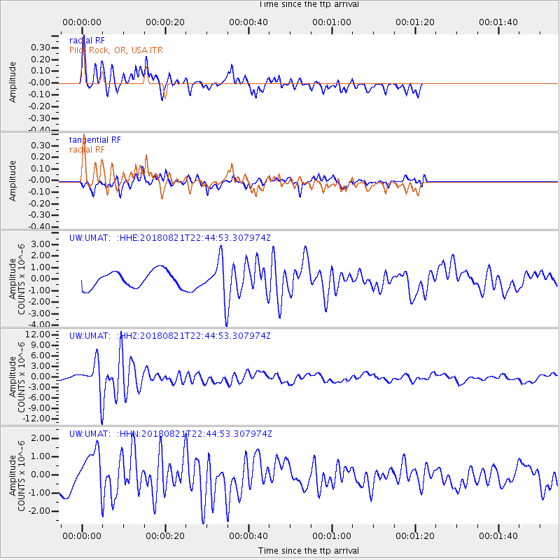
UMAT Pilot Rock, OR, USA - Earthquake Result Viewer
*The percent match for this event was below the threshold and hence no stack was calculated.
| Earthquake location: |
Vanuatu Islands |
| Earthquake latitude/longitude: |
-16.0/168.2 |
| Earthquake time(UTC): |
2018/08/21 (233) 22:32:27 GMT |
| Earthquake Depth: |
13 km |
| Earthquake Magnitude: |
6.5 Mww |
| Earthquake Catalog/Contributor: |
NEIC PDE/us |
|
| Network: |
UW Pacific Northwest Regional Seismic Network |
| Station: |
UMAT Pilot Rock, OR, USA |
| Lat/Lon: |
45.29 N/118.96 W |
| Elevation: |
1318 m |
|
| Distance: |
89.7 deg |
| Az: |
42.427 deg |
| Baz: |
246.796 deg |
| Ray Param: |
$rayparam |
*The percent match for this event was below the threshold and hence was not used in the summary stack. |
|
| Radial Match: |
74.86573 % |
| Radial Bump: |
312 |
| Transverse Match: |
77.24159 % |
| Transverse Bump: |
370 |
| SOD ConfigId: |
13570011 |
| Insert Time: |
2019-04-30 22:47:22.383 +0000 |
| GWidth: |
2.5 |
| Max Bumps: |
400 |
| Tol: |
0.001 |
|
Signal To Noise
| Channel | StoN | STA | LTA |
| UW:UMAT: :HHZ:20180821T22:44:53.307974Z | 3.4859297 | 4.514344E-6 | 1.2950185E-6 |
| UW:UMAT: :HHN:20180821T22:44:53.307974Z | 3.0030088 | 1.1350846E-6 | 3.7798245E-7 |
| UW:UMAT: :HHE:20180821T22:44:53.307974Z | 1.9346154 | 1.3678632E-6 | 7.0704664E-7 |
| Arrivals |
| Ps | |
| PpPs | |
| PsPs/PpSs | |


