You are here: Home > Network List > TA - USArray Transportable Network (new EarthScope stations) Stations List
> Station S21A Coal Bank Pass, Durango, CO, USA > Earthquake Result Viewer
S21A Coal Bank Pass, Durango, CO, USA - Earthquake Result Viewer
| Earthquake location: |
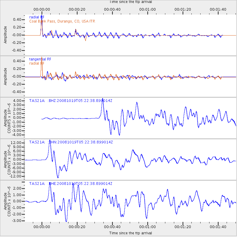
Tonga Islands |
| Earthquake latitude/longitude: |
-21.9/-173.8 |
| Earthquake time(UTC): |
2008/10/19 (293) 05:10:33 GMT |
| Earthquake Depth: |
29 km |
| Earthquake Magnitude: |
6.8 MB, 7.0 MS, 6.9 MW, 6.9 MW |
| Earthquake Catalog/Contributor: |
WHDF/NEIC |
|
| Network: |
TA USArray Transportable Network (new EarthScope stations) |
| Station: |
S21A Coal Bank Pass, Durango, CO, USA |
| Lat/Lon: |
37.66 N/107.79 W |
| Elevation: |
2723 m |
|
| Distance: |
85.7 deg |
| Az: |
46.649 deg |
| Baz: |
238.338 deg |
| Ray Param: |
0.044512093 |
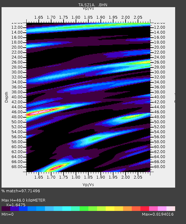
| Estimated Moho Depth: |
46.0 km |
| Estimated Crust Vp/Vs: |
1.65 |
| Assumed Crust Vp: |
6.159 km/s |
| Estimated Crust Vs: |
3.738 km/s |
| Estimated Crust Poisson's Ratio: |
0.21 |
|
| Radial Match: |
97.71496 % |
| Radial Bump: |
400 |
| Transverse Match: |
91.73801 % |
| Transverse Bump: |
400 |
| SOD ConfigId: |
2556 |
| Insert Time: |
2010-03-06 14:36:19.012 +0000 |
| GWidth: |
2.5 |
| Max Bumps: |
400 |
| Tol: |
0.001 |
|
Signal To Noise
| Channel | StoN | STA | LTA |
| TA:S21A: :BHN:20081019T05:22:38.899014Z | 88.79638 | 5.410765E-6 | 6.093452E-8 |
| TA:S21A: :BHE:20081019T05:22:38.899014Z | 13.424618 | 1.089014E-6 | 8.112067E-8 |
| TA:S21A: :BHZ:20081019T05:22:38.899014Z | 23.746754 | 1.7331561E-6 | 7.298497E-8 |
| Arrivals |
| Ps | 5.0 SECOND |
| PpPs | 19 SECOND |
| PsPs/PpSs | 24 SECOND |


