You are here: Home > Network List > LD - Lamont-Doherty Cooperative Seismographic Network Stations List
> Station GEDE Greenville, DE, USA > Earthquake Result Viewer
GEDE Greenville, DE, USA - Earthquake Result Viewer
| Earthquake location: |
Off Coast Of Oregon |
| Earthquake latitude/longitude: |
43.6/-127.6 |
| Earthquake time(UTC): |
2018/08/22 (234) 09:31:47 GMT |
| Earthquake Depth: |
10 km |
| Earthquake Magnitude: |
6.2 Mww |
| Earthquake Catalog/Contributor: |
NEIC PDE/us |
|
| Network: |
LD Lamont-Doherty Cooperative Seismographic Network |
| Station: |
GEDE Greenville, DE, USA |
| Lat/Lon: |
39.81 N/75.64 W |
| Elevation: |
105 m |
|
| Distance: |
38.5 deg |
| Az: |
77.315 deg |
| Baz: |
293.154 deg |
| Ray Param: |
0.0755526 |
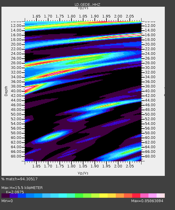
| Estimated Moho Depth: |
15.5 km |
| Estimated Crust Vp/Vs: |
2.10 |
| Assumed Crust Vp: |
6.287 km/s |
| Estimated Crust Vs: |
2.998 km/s |
| Estimated Crust Poisson's Ratio: |
0.35 |
|
| Radial Match: |
94.30517 % |
| Radial Bump: |
228 |
| Transverse Match: |
73.472565 % |
| Transverse Bump: |
347 |
| SOD ConfigId: |
13570011 |
| Insert Time: |
2019-04-30 22:51:22.856 +0000 |
| GWidth: |
2.5 |
| Max Bumps: |
400 |
| Tol: |
0.001 |
|

Signal To Noise
| Channel | StoN | STA | LTA |
| LD:GEDE: :HHZ:20180822T09:38:38.109998Z | 10.728016 | 1.5627105E-6 | 1.4566632E-7 |
| LD:GEDE: :HHN:20180822T09:38:38.109998Z | 1.3118191 | 1.8394056E-7 | 1.4021794E-7 |
| LD:GEDE: :HHE:20180822T09:38:38.109998Z | 4.938379 | 6.8063787E-7 | 1.3782618E-7 |
| Arrivals |
| Ps | 2.9 SECOND |
| PpPs | 7.2 SECOND |
| PsPs/PpSs | 10 SECOND |


