You are here: Home > Network List > TA - USArray Transportable Network (new EarthScope stations) Stations List
> Station S21A Coal Bank Pass, Durango, CO, USA > Earthquake Result Viewer
S21A Coal Bank Pass, Durango, CO, USA - Earthquake Result Viewer
| Earthquake location: |
Andreanof Islands, Aleutian Is. |
| Earthquake latitude/longitude: |
51.4/-179.5 |
| Earthquake time(UTC): |
2007/12/19 (353) 09:30:27 GMT |
| Earthquake Depth: |
29 km |
| Earthquake Magnitude: |
6.4 MB, 7.1 MS, 7.1 MW, 7.0 MW |
| Earthquake Catalog/Contributor: |
WHDF/NEIC |
|
| Network: |
TA USArray Transportable Network (new EarthScope stations) |
| Station: |
S21A Coal Bank Pass, Durango, CO, USA |
| Lat/Lon: |
37.66 N/107.79 W |
| Elevation: |
2723 m |
|
| Distance: |
51.0 deg |
| Az: |
76.019 deg |
| Baz: |
309.952 deg |
| Ray Param: |
0.06766812 |
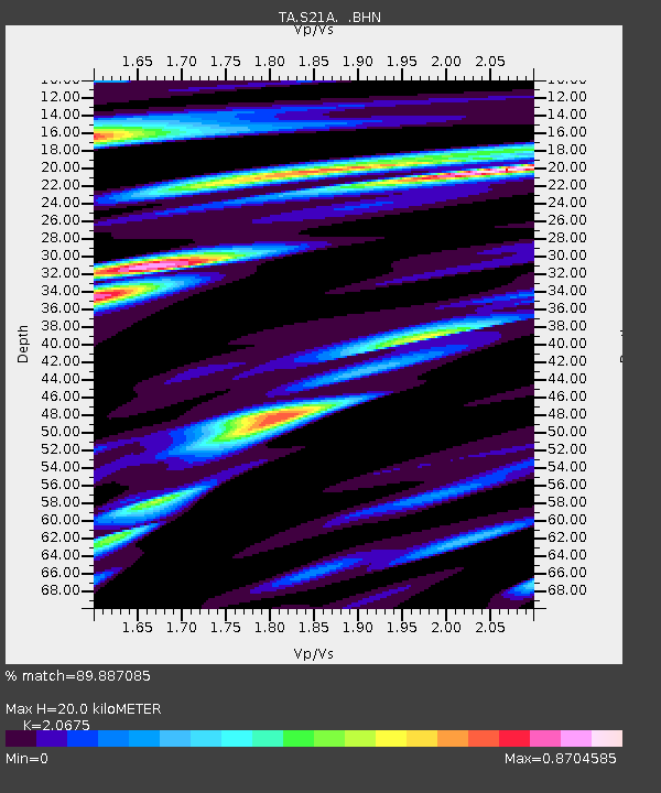
| Estimated Moho Depth: |
20.0 km |
| Estimated Crust Vp/Vs: |
2.07 |
| Assumed Crust Vp: |
6.159 km/s |
| Estimated Crust Vs: |
2.979 km/s |
| Estimated Crust Poisson's Ratio: |
0.35 |
|
| Radial Match: |
89.887085 % |
| Radial Bump: |
400 |
| Transverse Match: |
77.61372 % |
| Transverse Bump: |
400 |
| SOD ConfigId: |
2564 |
| Insert Time: |
2010-03-06 14:36:52.147 +0000 |
| GWidth: |
2.5 |
| Max Bumps: |
400 |
| Tol: |
0.001 |
|

Signal To Noise
| Channel | StoN | STA | LTA |
| TA:S21A: :BHN:20071219T09:38:55.300009Z | 9.983941 | 1.344234E-6 | 1.3463962E-7 |
| TA:S21A: :BHE:20071219T09:38:55.300009Z | 3.1353846 | 1.313511E-6 | 4.189314E-7 |
| TA:S21A: :BHZ:20071219T09:38:55.300009Z | 4.209703 | 3.580185E-6 | 8.5046025E-7 |
| Arrivals |
| Ps | 3.6 SECOND |
| PpPs | 9.5 SECOND |
| PsPs/PpSs | 13 SECOND |


