You are here: Home > Network List > N4 - Central and EAstern US Network Stations List
> Station O49A Covington, OH, USA > Earthquake Result Viewer
O49A Covington, OH, USA - Earthquake Result Viewer
| Earthquake location: |
Off Coast Of Oregon |
| Earthquake latitude/longitude: |
43.6/-127.6 |
| Earthquake time(UTC): |
2018/08/22 (234) 09:31:47 GMT |
| Earthquake Depth: |
10 km |
| Earthquake Magnitude: |
6.2 Mww |
| Earthquake Catalog/Contributor: |
NEIC PDE/us |
|
| Network: |
N4 Central and EAstern US Network |
| Station: |
O49A Covington, OH, USA |
| Lat/Lon: |
40.19 N/84.34 W |
| Elevation: |
292 m |
|
| Distance: |
32.1 deg |
| Az: |
81.02 deg |
| Baz: |
290.607 deg |
| Ray Param: |
0.07879021 |
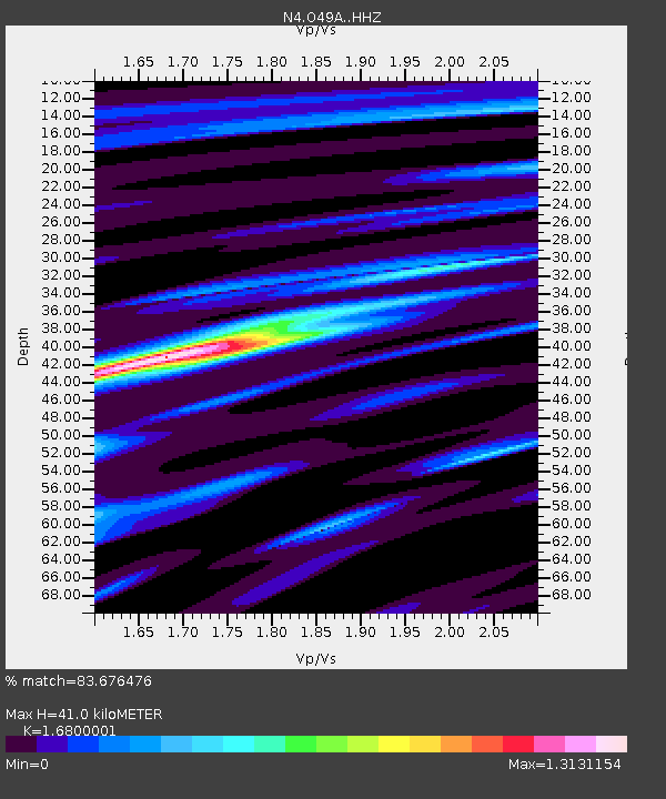
| Estimated Moho Depth: |
41.0 km |
| Estimated Crust Vp/Vs: |
1.68 |
| Assumed Crust Vp: |
6.498 km/s |
| Estimated Crust Vs: |
3.868 km/s |
| Estimated Crust Poisson's Ratio: |
0.23 |
|
| Radial Match: |
83.676476 % |
| Radial Bump: |
335 |
| Transverse Match: |
68.161354 % |
| Transverse Bump: |
400 |
| SOD ConfigId: |
13570011 |
| Insert Time: |
2019-04-30 22:52:27.705 +0000 |
| GWidth: |
2.5 |
| Max Bumps: |
400 |
| Tol: |
0.001 |
|

Signal To Noise
| Channel | StoN | STA | LTA |
| N4:O49A: :HHZ:20180822T09:37:43.669995Z | 11.284881 | 1.2801183E-6 | 1.1343659E-7 |
| N4:O49A: :HHN:20180822T09:37:43.669995Z | 1.5636662 | 1.6827497E-7 | 1.0761566E-7 |
| N4:O49A: :HHE:20180822T09:37:43.669995Z | 10.788604 | 7.834586E-7 | 7.261909E-8 |
| Arrivals |
| Ps | 4.7 SECOND |
| PpPs | 16 SECOND |
| PsPs/PpSs | 20 SECOND |


