You are here: Home > Network List > TA - USArray Transportable Network (new EarthScope stations) Stations List
> Station S21A Coal Bank Pass, Durango, CO, USA > Earthquake Result Viewer
S21A Coal Bank Pass, Durango, CO, USA - Earthquake Result Viewer
| Earthquake location: |
Near East Coast Of Honshu, Japan |
| Earthquake latitude/longitude: |
35.5/140.9 |
| Earthquake time(UTC): |
2009/06/06 (157) 05:52:43 GMT |
| Earthquake Depth: |
34 km |
| Earthquake Magnitude: |
5.8 MB, 5.4 MS, 5.8 MW, 5.7 MW |
| Earthquake Catalog/Contributor: |
WHDF/NEIC |
|
| Network: |
TA USArray Transportable Network (new EarthScope stations) |
| Station: |
S21A Coal Bank Pass, Durango, CO, USA |
| Lat/Lon: |
37.66 N/107.79 W |
| Elevation: |
2723 m |
|
| Distance: |
83.3 deg |
| Az: |
48.115 deg |
| Baz: |
310.039 deg |
| Ray Param: |
0.046228565 |
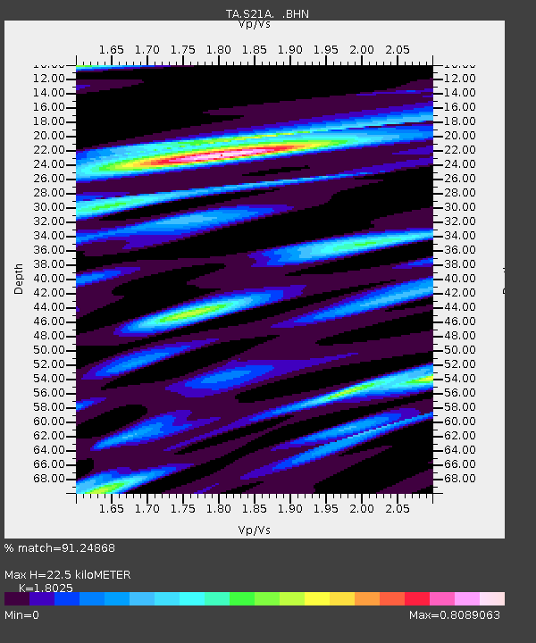
| Estimated Moho Depth: |
22.5 km |
| Estimated Crust Vp/Vs: |
1.80 |
| Assumed Crust Vp: |
6.159 km/s |
| Estimated Crust Vs: |
3.417 km/s |
| Estimated Crust Poisson's Ratio: |
0.28 |
|
| Radial Match: |
91.24868 % |
| Radial Bump: |
400 |
| Transverse Match: |
83.96557 % |
| Transverse Bump: |
400 |
| SOD ConfigId: |
2648 |
| Insert Time: |
2010-03-06 14:36:56.642 +0000 |
| GWidth: |
2.5 |
| Max Bumps: |
400 |
| Tol: |
0.001 |
|

Signal To Noise
| Channel | StoN | STA | LTA |
| TA:S21A: :BHN:20090606T06:04:35.523999Z | 22.382183 | 9.082223E-7 | 4.0577916E-8 |
| TA:S21A: :BHE:20090606T06:04:35.523999Z | 3.3672965 | 1.4137869E-7 | 4.1985817E-8 |
| TA:S21A: :BHZ:20090606T06:04:35.523999Z | 7.411994 | 2.780233E-7 | 3.750992E-8 |
| Arrivals |
| Ps | 3.0 SECOND |
| PpPs | 10 SECOND |
| PsPs/PpSs | 13 SECOND |


