You are here: Home > Network List > TA - USArray Transportable Network (new EarthScope stations) Stations List
> Station S21A Coal Bank Pass, Durango, CO, USA > Earthquake Result Viewer
S21A Coal Bank Pass, Durango, CO, USA - Earthquake Result Viewer
| Earthquake location: |
Kuril Islands |
| Earthquake latitude/longitude: |
46.5/153.3 |
| Earthquake time(UTC): |
2008/06/23 (175) 12:32:12 GMT |
| Earthquake Depth: |
10 km |
| Earthquake Magnitude: |
5.6 MB, 5.2 MS, 5.6 MW, 5.6 MW |
| Earthquake Catalog/Contributor: |
WHDF/NEIC |
|
| Network: |
TA USArray Transportable Network (new EarthScope stations) |
| Station: |
S21A Coal Bank Pass, Durango, CO, USA |
| Lat/Lon: |
37.66 N/107.79 W |
| Elevation: |
2723 m |
|
| Distance: |
69.2 deg |
| Az: |
56.975 deg |
| Baz: |
313.11 deg |
| Ray Param: |
0.055783357 |
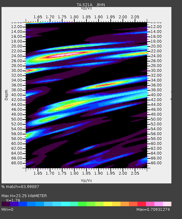
| Estimated Moho Depth: |
23.25 km |
| Estimated Crust Vp/Vs: |
1.76 |
| Assumed Crust Vp: |
6.159 km/s |
| Estimated Crust Vs: |
3.499 km/s |
| Estimated Crust Poisson's Ratio: |
0.26 |
|
| Radial Match: |
83.99887 % |
| Radial Bump: |
400 |
| Transverse Match: |
67.96429 % |
| Transverse Bump: |
400 |
| SOD ConfigId: |
2504 |
| Insert Time: |
2010-03-06 14:37:26.207 +0000 |
| GWidth: |
2.5 |
| Max Bumps: |
400 |
| Tol: |
0.001 |
|

Signal To Noise
| Channel | StoN | STA | LTA |
| TA:S21A: :BHN:20080623T12:42:48.248994Z | 5.80017 | 1.1806896E-7 | 2.035612E-8 |
| TA:S21A: :BHE:20080623T12:42:48.248994Z | 1.9669306 | 4.2955364E-8 | 2.183878E-8 |
| TA:S21A: :BHZ:20080623T12:42:48.248994Z | 2.8394437 | 5.277533E-8 | 1.8586503E-8 |
| Arrivals |
| Ps | 3.0 SECOND |
| PpPs | 10 SECOND |
| PsPs/PpSs | 13 SECOND |


