You are here: Home > Network List > TA - USArray Transportable Network (new EarthScope stations) Stations List
> Station C16K Lisburne Hills, AK, USA > Earthquake Result Viewer
C16K Lisburne Hills, AK, USA - Earthquake Result Viewer
| Earthquake location: |
Off Coast Of Oregon |
| Earthquake latitude/longitude: |
43.6/-127.6 |
| Earthquake time(UTC): |
2018/08/22 (234) 09:31:47 GMT |
| Earthquake Depth: |
10 km |
| Earthquake Magnitude: |
6.2 Mww |
| Earthquake Catalog/Contributor: |
NEIC PDE/us |
|
| Network: |
TA USArray Transportable Network (new EarthScope stations) |
| Station: |
C16K Lisburne Hills, AK, USA |
| Lat/Lon: |
68.27 N/165.34 W |
| Elevation: |
102 m |
|
| Distance: |
31.6 deg |
| Az: |
334.193 deg |
| Baz: |
121.915 deg |
| Ray Param: |
0.07902281 |
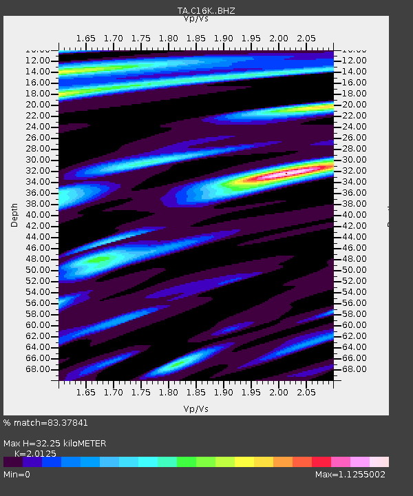
| Estimated Moho Depth: |
32.25 km |
| Estimated Crust Vp/Vs: |
2.01 |
| Assumed Crust Vp: |
5.906 km/s |
| Estimated Crust Vs: |
2.935 km/s |
| Estimated Crust Poisson's Ratio: |
0.34 |
|
| Radial Match: |
83.37841 % |
| Radial Bump: |
400 |
| Transverse Match: |
71.384964 % |
| Transverse Bump: |
400 |
| SOD ConfigId: |
13570011 |
| Insert Time: |
2019-04-30 22:54:26.248 +0000 |
| GWidth: |
2.5 |
| Max Bumps: |
400 |
| Tol: |
0.001 |
|
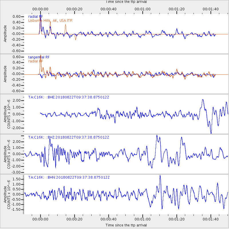
Signal To Noise
| Channel | StoN | STA | LTA |
| TA:C16K: :BHZ:20180822T09:37:38.875012Z | 5.5640187 | 1.0521538E-6 | 1.8909964E-7 |
| TA:C16K: :BHN:20180822T09:37:38.875012Z | 1.468431 | 2.5310146E-7 | 1.7236184E-7 |
| TA:C16K: :BHE:20180822T09:37:38.875012Z | 2.645008 | 4.5887964E-7 | 1.7348894E-7 |
| Arrivals |
| Ps | 5.9 SECOND |
| PpPs | 16 SECOND |
| PsPs/PpSs | 21 SECOND |


