You are here: Home > Network List > TA - USArray Transportable Network (new EarthScope stations) Stations List
> Station C17K DeLong Mountains, AK, USA > Earthquake Result Viewer
C17K DeLong Mountains, AK, USA - Earthquake Result Viewer
| Earthquake location: |
Off Coast Of Oregon |
| Earthquake latitude/longitude: |
43.6/-127.6 |
| Earthquake time(UTC): |
2018/08/22 (234) 09:31:47 GMT |
| Earthquake Depth: |
10 km |
| Earthquake Magnitude: |
6.2 Mww |
| Earthquake Catalog/Contributor: |
NEIC PDE/us |
|
| Network: |
TA USArray Transportable Network (new EarthScope stations) |
| Station: |
C17K DeLong Mountains, AK, USA |
| Lat/Lon: |
68.48 N/163.18 W |
| Elevation: |
498 m |
|
| Distance: |
31.0 deg |
| Az: |
335.369 deg |
| Baz: |
124.932 deg |
| Ray Param: |
0.079182744 |
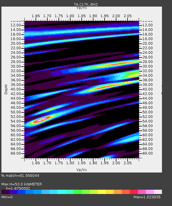
| Estimated Moho Depth: |
53.0 km |
| Estimated Crust Vp/Vs: |
1.68 |
| Assumed Crust Vp: |
5.906 km/s |
| Estimated Crust Vs: |
3.526 km/s |
| Estimated Crust Poisson's Ratio: |
0.22 |
|
| Radial Match: |
81.558044 % |
| Radial Bump: |
400 |
| Transverse Match: |
64.78143 % |
| Transverse Bump: |
400 |
| SOD ConfigId: |
13570011 |
| Insert Time: |
2019-04-30 22:54:26.655 +0000 |
| GWidth: |
2.5 |
| Max Bumps: |
400 |
| Tol: |
0.001 |
|

Signal To Noise
| Channel | StoN | STA | LTA |
| TA:C17K: :BHZ:20180822T09:37:33.974988Z | 4.4570456 | 9.695253E-7 | 2.1752646E-7 |
| TA:C17K: :BHN:20180822T09:37:33.974988Z | 1.6498375 | 3.100755E-7 | 1.8794306E-7 |
| TA:C17K: :BHE:20180822T09:37:33.974988Z | 2.2662258 | 3.9551955E-7 | 1.7452787E-7 |
| Arrivals |
| Ps | 6.5 SECOND |
| PpPs | 22 SECOND |
| PsPs/PpSs | 29 SECOND |


