You are here: Home > Network List > TA - USArray Transportable Network (new EarthScope stations) Stations List
> Station P49A Miami Univ. Ecology Research Center, OH, USA > Earthquake Result Viewer
P49A Miami Univ. Ecology Research Center, OH, USA - Earthquake Result Viewer
| Earthquake location: |
Off Coast Of Oregon |
| Earthquake latitude/longitude: |
43.6/-127.6 |
| Earthquake time(UTC): |
2018/08/22 (234) 09:31:47 GMT |
| Earthquake Depth: |
10 km |
| Earthquake Magnitude: |
6.2 Mww |
| Earthquake Catalog/Contributor: |
NEIC PDE/us |
|
| Network: |
TA USArray Transportable Network (new EarthScope stations) |
| Station: |
P49A Miami Univ. Ecology Research Center, OH, USA |
| Lat/Lon: |
39.53 N/84.72 W |
| Elevation: |
272 m |
|
| Distance: |
32.1 deg |
| Az: |
82.366 deg |
| Baz: |
291.504 deg |
| Ray Param: |
0.07880686 |
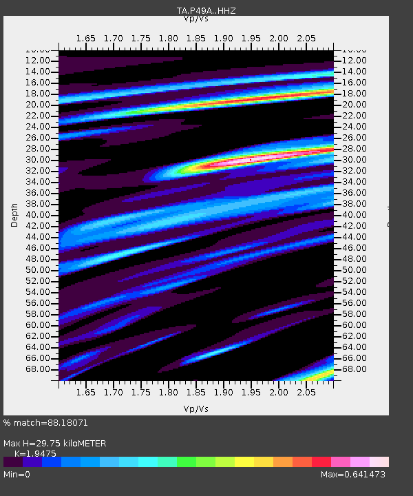
| Estimated Moho Depth: |
29.75 km |
| Estimated Crust Vp/Vs: |
1.95 |
| Assumed Crust Vp: |
6.498 km/s |
| Estimated Crust Vs: |
3.336 km/s |
| Estimated Crust Poisson's Ratio: |
0.32 |
|
| Radial Match: |
88.18071 % |
| Radial Bump: |
400 |
| Transverse Match: |
57.13636 % |
| Transverse Bump: |
400 |
| SOD ConfigId: |
13570011 |
| Insert Time: |
2019-04-30 22:54:33.581 +0000 |
| GWidth: |
2.5 |
| Max Bumps: |
400 |
| Tol: |
0.001 |
|

Signal To Noise
| Channel | StoN | STA | LTA |
| TA:P49A: :HHZ:20180822T09:37:43.329999Z | 8.073618 | 1.3869162E-6 | 1.7178373E-7 |
| TA:P49A: :HHN:20180822T09:37:43.329999Z | 2.2307756 | 2.5160233E-7 | 1.12786935E-7 |
| TA:P49A: :HHE:20180822T09:37:43.329999Z | 4.2589045 | 7.0380503E-7 | 1.6525495E-7 |
| Arrivals |
| Ps | 4.7 SECOND |
| PpPs | 13 SECOND |
| PsPs/PpSs | 17 SECOND |


