You are here: Home > Network List > TA - USArray Transportable Network (new EarthScope stations) Stations List
> Station S21A Coal Bank Pass, Durango, CO, USA > Earthquake Result Viewer
S21A Coal Bank Pass, Durango, CO, USA - Earthquake Result Viewer

| Earthquake location: |
Kuril Islands |
| Earthquake latitude/longitude: |
45.4/151.0 |
| Earthquake time(UTC): |
2008/07/06 (188) 09:08:20 GMT |
| Earthquake Depth: |
10 km |
| Earthquake Magnitude: |
5.8 MB, 5.4 MS, 5.7 MW, 5.7 MW |
| Earthquake Catalog/Contributor: |
WHDF/NEIC |
|
| Network: |
TA USArray Transportable Network (new EarthScope stations) |
| Station: |
S21A Coal Bank Pass, Durango, CO, USA |
| Lat/Lon: |
37.66 N/107.79 W |
| Elevation: |
2723 m |
|
| Distance: |
71.2 deg |
| Az: |
55.318 deg |
| Baz: |
313.098 deg |
| Ray Param: |
0.054493144 |
| Estimated Moho Depth: |
56.75 km |
| Estimated Crust Vp/Vs: |
1.60 |
| Assumed Crust Vp: |
6.159 km/s |
| Estimated Crust Vs: |
3.849 km/s |
| Estimated Crust Poisson's Ratio: |
0.18 |
|
| Radial Match: |
86.47059 % |
| Radial Bump: |
400 |
| Transverse Match: |
69.97792 % |
| Transverse Bump: |
400 |
| SOD ConfigId: |
2504 |
| Insert Time: |
2010-03-06 14:37:32.197 +0000 |
| GWidth: |
2.5 |
| Max Bumps: |
400 |
| Tol: |
0.001 |
|
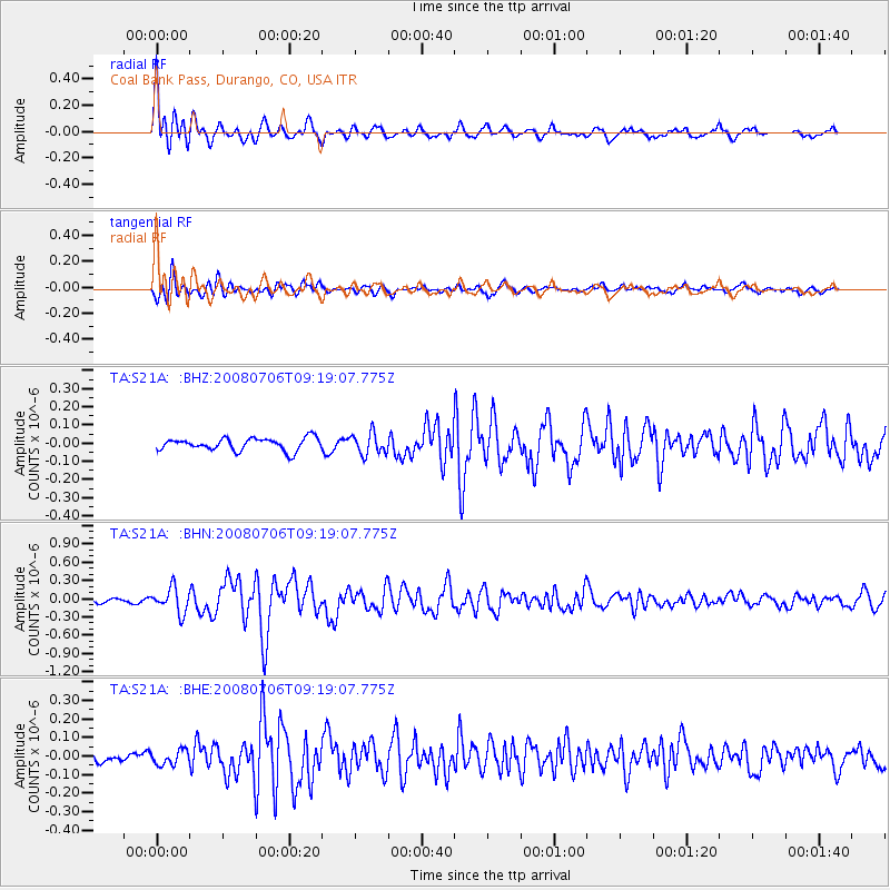
Signal To Noise
| Channel | StoN | STA | LTA |
| TA:S21A: :BHN:20080706T09:19:07.775Z | 4.2864537 | 2.0272402E-7 | 4.729411E-8 |
| TA:S21A: :BHE:20080706T09:19:07.775Z | 1.1085354 | 3.9810796E-8 | 3.591297E-8 |
| TA:S21A: :BHZ:20080706T09:19:07.775Z | 1.7221817 | 5.8802055E-8 | 3.4143934E-8 |
| Arrivals |
| Ps | 5.7 SECOND |
| PpPs | 23 SECOND |
| PsPs/PpSs | 29 SECOND |


