You are here: Home > Network List > TA - USArray Transportable Network (new EarthScope stations) Stations List
> Station S21A Coal Bank Pass, Durango, CO, USA > Earthquake Result Viewer
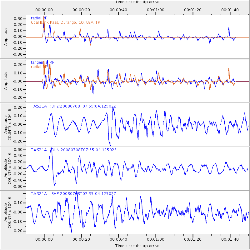
S21A Coal Bank Pass, Durango, CO, USA - Earthquake Result Viewer
*The percent match for this event was below the threshold and hence no stack was calculated.
| Earthquake location: |
Ryukyu Islands, Japan |
| Earthquake latitude/longitude: |
27.5/128.3 |
| Earthquake time(UTC): |
2008/07/08 (190) 07:42:10 GMT |
| Earthquake Depth: |
43 km |
| Earthquake Magnitude: |
6.0 MB, 5.5 MS, 6.0 MW, 6.0 MW |
| Earthquake Catalog/Contributor: |
WHDF/NEIC |
|
| Network: |
TA USArray Transportable Network (new EarthScope stations) |
| Station: |
S21A Coal Bank Pass, Durango, CO, USA |
| Lat/Lon: |
37.66 N/107.79 W |
| Elevation: |
2723 m |
|
| Distance: |
96.5 deg |
| Az: |
41.541 deg |
| Baz: |
312.094 deg |
| Ray Param: |
$rayparam |
*The percent match for this event was below the threshold and hence was not used in the summary stack. |
|
| Radial Match: |
73.879 % |
| Radial Bump: |
302 |
| Transverse Match: |
75.94628 % |
| Transverse Bump: |
324 |
| SOD ConfigId: |
2504 |
| Insert Time: |
2010-03-06 14:37:35.175 +0000 |
| GWidth: |
2.5 |
| Max Bumps: |
400 |
| Tol: |
0.001 |
|
Signal To Noise
| Channel | StoN | STA | LTA |
| TA:S21A: :BHN:20080708T07:55:04.12502Z | 2.3551424 | 2.9720155E-7 | 1.261926E-7 |
| TA:S21A: :BHE:20080708T07:55:04.12502Z | 1.1166439 | 5.1198434E-8 | 4.585028E-8 |
| TA:S21A: :BHZ:20080708T07:55:04.12502Z | 1.2118195 | 8.056225E-8 | 6.64804E-8 |
| Arrivals |
| Ps | |
| PpPs | |
| PsPs/PpSs | |


