You are here: Home > Network List > TA - USArray Transportable Network (new EarthScope stations) Stations List
> Station S21A Coal Bank Pass, Durango, CO, USA > Earthquake Result Viewer
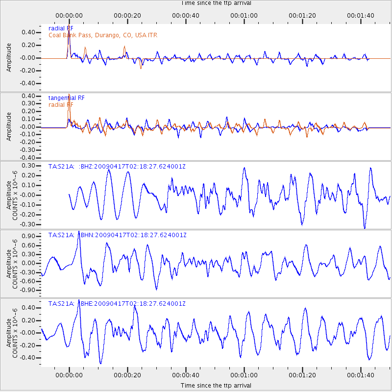
S21A Coal Bank Pass, Durango, CO, USA - Earthquake Result Viewer
*The percent match for this event was below the threshold and hence no stack was calculated.
| Earthquake location: |
Near Coast Of Northern Chile |
| Earthquake latitude/longitude: |
-19.6/-70.5 |
| Earthquake time(UTC): |
2009/04/17 (107) 02:08:08 GMT |
| Earthquake Depth: |
25 km |
| Earthquake Magnitude: |
5.8 MB, 5.8 MS, 6.1 MW, 6.1 MW |
| Earthquake Catalog/Contributor: |
WHDF/NEIC |
|
| Network: |
TA USArray Transportable Network (new EarthScope stations) |
| Station: |
S21A Coal Bank Pass, Durango, CO, USA |
| Lat/Lon: |
37.66 N/107.79 W |
| Elevation: |
2723 m |
|
| Distance: |
66.9 deg |
| Az: |
328.469 deg |
| Baz: |
141.588 deg |
| Ray Param: |
$rayparam |
*The percent match for this event was below the threshold and hence was not used in the summary stack. |
|
| Radial Match: |
63.083656 % |
| Radial Bump: |
395 |
| Transverse Match: |
59.73411 % |
| Transverse Bump: |
369 |
| SOD ConfigId: |
2658 |
| Insert Time: |
2010-03-06 14:37:38.050 +0000 |
| GWidth: |
2.5 |
| Max Bumps: |
400 |
| Tol: |
0.001 |
|
Signal To Noise
| Channel | StoN | STA | LTA |
| TA:S21A: :BHN:20090417T02:18:27.624001Z | 2.5345297 | 4.415901E-7 | 1.742296E-7 |
| TA:S21A: :BHE:20090417T02:18:27.624001Z | 3.9553385 | 2.4990248E-7 | 6.318106E-8 |
| TA:S21A: :BHZ:20090417T02:18:27.624001Z | 0.6358963 | 9.038575E-8 | 1.4213911E-7 |
| Arrivals |
| Ps | |
| PpPs | |
| PsPs/PpSs | |


