You are here: Home > Network List > TA - USArray Transportable Network (new EarthScope stations) Stations List
> Station S21A Coal Bank Pass, Durango, CO, USA > Earthquake Result Viewer
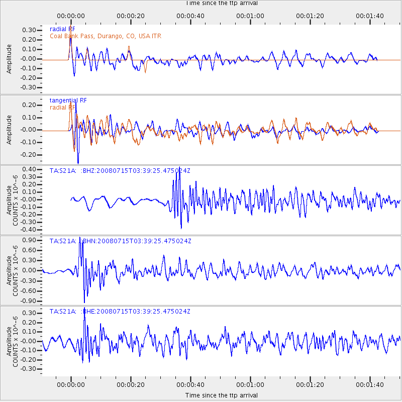
S21A Coal Bank Pass, Durango, CO, USA - Earthquake Result Viewer
*The percent match for this event was below the threshold and hence no stack was calculated.
| Earthquake location: |
Dodecanese Islands, Greece |
| Earthquake latitude/longitude: |
35.8/27.9 |
| Earthquake time(UTC): |
2008/07/15 (197) 03:26:34 GMT |
| Earthquake Depth: |
52 km |
| Earthquake Magnitude: |
6.5 MB, 6.4 MW, 6.4 MW |
| Earthquake Catalog/Contributor: |
WHDF/NEIC |
|
| Network: |
TA USArray Transportable Network (new EarthScope stations) |
| Station: |
S21A Coal Bank Pass, Durango, CO, USA |
| Lat/Lon: |
37.66 N/107.79 W |
| Elevation: |
2723 m |
|
| Distance: |
96.1 deg |
| Az: |
326.086 deg |
| Baz: |
34.857 deg |
| Ray Param: |
$rayparam |
*The percent match for this event was below the threshold and hence was not used in the summary stack. |
|
| Radial Match: |
79.399284 % |
| Radial Bump: |
400 |
| Transverse Match: |
76.182106 % |
| Transverse Bump: |
400 |
| SOD ConfigId: |
2504 |
| Insert Time: |
2010-03-06 14:37:52.045 +0000 |
| GWidth: |
2.5 |
| Max Bumps: |
400 |
| Tol: |
0.001 |
|
Signal To Noise
| Channel | StoN | STA | LTA |
| TA:S21A: :BHN:20080715T03:39:25.475024Z | 6.1309404 | 4.148399E-7 | 6.7663336E-8 |
| TA:S21A: :BHE:20080715T03:39:25.475024Z | 2.9893978 | 1.1404903E-7 | 3.815117E-8 |
| TA:S21A: :BHZ:20080715T03:39:25.475024Z | 2.0785189 | 9.515164E-8 | 4.577858E-8 |
| Arrivals |
| Ps | |
| PpPs | |
| PsPs/PpSs | |


