You are here: Home > Network List > TA - USArray Transportable Network (new EarthScope stations) Stations List
> Station S21A Coal Bank Pass, Durango, CO, USA > Earthquake Result Viewer
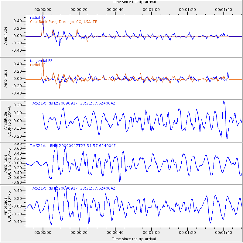
S21A Coal Bank Pass, Durango, CO, USA - Earthquake Result Viewer
*The percent match for this event was below the threshold and hence no stack was calculated.
| Earthquake location: |
Easter Island Region |
| Earthquake latitude/longitude: |
-29.1/-112.3 |
| Earthquake time(UTC): |
2009/09/17 (260) 23:21:38 GMT |
| Earthquake Depth: |
10 km |
| Earthquake Magnitude: |
5.7 MB, 6.0 MS, 6.2 MW, 6.2 MW |
| Earthquake Catalog/Contributor: |
WHDF/NEIC |
|
| Network: |
TA USArray Transportable Network (new EarthScope stations) |
| Station: |
S21A Coal Bank Pass, Durango, CO, USA |
| Lat/Lon: |
37.66 N/107.79 W |
| Elevation: |
2723 m |
|
| Distance: |
66.6 deg |
| Az: |
3.869 deg |
| Baz: |
184.266 deg |
| Ray Param: |
$rayparam |
*The percent match for this event was below the threshold and hence was not used in the summary stack. |
|
| Radial Match: |
77.21788 % |
| Radial Bump: |
366 |
| Transverse Match: |
73.557846 % |
| Transverse Bump: |
400 |
| SOD ConfigId: |
2622 |
| Insert Time: |
2010-03-06 14:38:15.302 +0000 |
| GWidth: |
2.5 |
| Max Bumps: |
400 |
| Tol: |
0.001 |
|
Signal To Noise
| Channel | StoN | STA | LTA |
| TA:S21A: :BHN:20090917T23:31:57.624004Z | 4.031922 | 3.1223837E-7 | 7.744157E-8 |
| TA:S21A: :BHE:20090917T23:31:57.624004Z | 2.8322966 | 2.1445928E-7 | 7.5719214E-8 |
| TA:S21A: :BHZ:20090917T23:31:57.624004Z | 1.3861521 | 9.113458E-8 | 6.574645E-8 |
| Arrivals |
| Ps | |
| PpPs | |
| PsPs/PpSs | |


