You are here: Home > Network List > TA - USArray Transportable Network (new EarthScope stations) Stations List
> Station S21A Coal Bank Pass, Durango, CO, USA > Earthquake Result Viewer
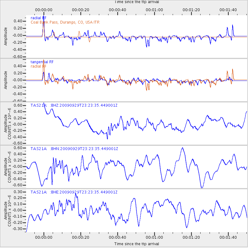
S21A Coal Bank Pass, Durango, CO, USA - Earthquake Result Viewer
*The percent match for this event was below the threshold and hence no stack was calculated.
| Earthquake location: |
Tonga Islands |
| Earthquake latitude/longitude: |
-15.6/-173.4 |
| Earthquake time(UTC): |
2009/09/29 (272) 23:11:51 GMT |
| Earthquake Depth: |
10 km |
| Earthquake Magnitude: |
5.5 MB |
| Earthquake Catalog/Contributor: |
WHDF/NEIC |
|
| Network: |
TA USArray Transportable Network (new EarthScope stations) |
| Station: |
S21A Coal Bank Pass, Durango, CO, USA |
| Lat/Lon: |
37.66 N/107.79 W |
| Elevation: |
2723 m |
|
| Distance: |
81.2 deg |
| Az: |
46.994 deg |
| Baz: |
242.613 deg |
| Ray Param: |
$rayparam |
*The percent match for this event was below the threshold and hence was not used in the summary stack. |
|
| Radial Match: |
53.141113 % |
| Radial Bump: |
307 |
| Transverse Match: |
54.725628 % |
| Transverse Bump: |
400 |
| SOD ConfigId: |
2622 |
| Insert Time: |
2010-03-06 14:38:15.954 +0000 |
| GWidth: |
2.5 |
| Max Bumps: |
400 |
| Tol: |
0.001 |
|
Signal To Noise
| Channel | StoN | STA | LTA |
| TA:S21A: :BHN:20090929T23:23:35.449001Z | 3.9303222 | 5.037877E-7 | 1.2817975E-7 |
| TA:S21A: :BHE:20090929T23:23:35.449001Z | 0.27750206 | 5.1826802E-8 | 1.8676187E-7 |
| TA:S21A: :BHZ:20090929T23:23:35.449001Z | 2.5567214 | 4.475298E-7 | 1.750405E-7 |
| Arrivals |
| Ps | |
| PpPs | |
| PsPs/PpSs | |


