You are here: Home > Network List > TA - USArray Transportable Network (new EarthScope stations) Stations List
> Station S21A Coal Bank Pass, Durango, CO, USA > Earthquake Result Viewer
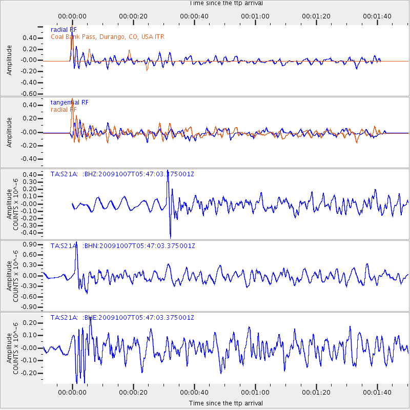
S21A Coal Bank Pass, Durango, CO, USA - Earthquake Result Viewer
*The percent match for this event was below the threshold and hence no stack was calculated.
| Earthquake location: |
Rat Islands, Aleutian Islands |
| Earthquake latitude/longitude: |
52.2/178.1 |
| Earthquake time(UTC): |
2009/10/07 (280) 05:38:37 GMT |
| Earthquake Depth: |
138 km |
| Earthquake Magnitude: |
5.6 MB, 5.6 MW, 5.6 MW |
| Earthquake Catalog/Contributor: |
WHDF/NEIC |
|
| Network: |
TA USArray Transportable Network (new EarthScope stations) |
| Station: |
S21A Coal Bank Pass, Durango, CO, USA |
| Lat/Lon: |
37.66 N/107.79 W |
| Elevation: |
2723 m |
|
| Distance: |
52.2 deg |
| Az: |
75.028 deg |
| Baz: |
311.415 deg |
| Ray Param: |
$rayparam |
*The percent match for this event was below the threshold and hence was not used in the summary stack. |
|
| Radial Match: |
69.46833 % |
| Radial Bump: |
400 |
| Transverse Match: |
67.03938 % |
| Transverse Bump: |
400 |
| SOD ConfigId: |
2622 |
| Insert Time: |
2010-03-06 14:38:16.555 +0000 |
| GWidth: |
2.5 |
| Max Bumps: |
400 |
| Tol: |
0.001 |
|
Signal To Noise
| Channel | StoN | STA | LTA |
| TA:S21A: :BHN:20091007T05:47:03.375001Z | 5.025611 | 3.651756E-7 | 7.266293E-8 |
| TA:S21A: :BHE:20091007T05:47:03.375001Z | 3.9860847 | 1.3980068E-7 | 3.507218E-8 |
| TA:S21A: :BHZ:20091007T05:47:03.375001Z | 3.8723161 | 1.924306E-7 | 4.9693927E-8 |
| Arrivals |
| Ps | |
| PpPs | |
| PsPs/PpSs | |


