You are here: Home > Network List > TA - USArray Transportable Network (new EarthScope stations) Stations List
> Station S21A Coal Bank Pass, Durango, CO, USA > Earthquake Result Viewer
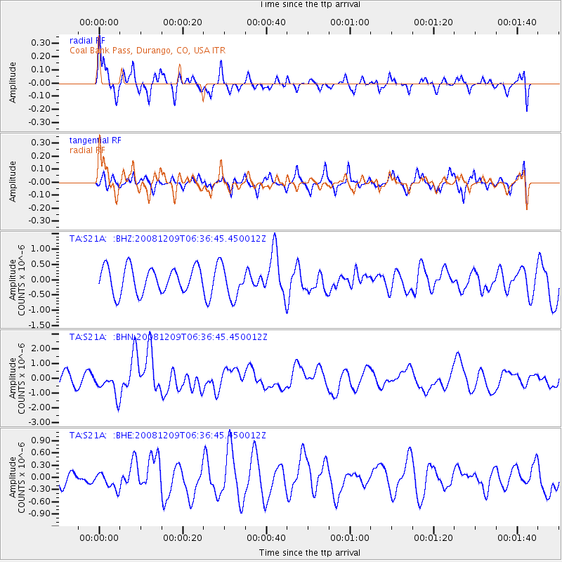
S21A Coal Bank Pass, Durango, CO, USA - Earthquake Result Viewer
*The percent match for this event was below the threshold and hence no stack was calculated.
| Earthquake location: |
Kermadec Islands Region |
| Earthquake latitude/longitude: |
-31.2/-176.9 |
| Earthquake time(UTC): |
2008/12/09 (344) 06:23:59 GMT |
| Earthquake Depth: |
18 km |
| Earthquake Magnitude: |
6.2 MB, 6.7 MS, 6.8 MW, 6.7 MW |
| Earthquake Catalog/Contributor: |
WHDF/NEIC |
|
| Network: |
TA USArray Transportable Network (new EarthScope stations) |
| Station: |
S21A Coal Bank Pass, Durango, CO, USA |
| Lat/Lon: |
37.66 N/107.79 W |
| Elevation: |
2723 m |
|
| Distance: |
94.1 deg |
| Az: |
48.028 deg |
| Baz: |
233.369 deg |
| Ray Param: |
$rayparam |
*The percent match for this event was below the threshold and hence was not used in the summary stack. |
|
| Radial Match: |
59.2156 % |
| Radial Bump: |
400 |
| Transverse Match: |
48.304615 % |
| Transverse Bump: |
375 |
| SOD ConfigId: |
2658 |
| Insert Time: |
2010-03-06 14:38:23.270 +0000 |
| GWidth: |
2.5 |
| Max Bumps: |
400 |
| Tol: |
0.001 |
|
Signal To Noise
| Channel | StoN | STA | LTA |
| TA:S21A: :BHN:20081209T06:36:45.450012Z | 2.2202606 | 8.080634E-7 | 3.639498E-7 |
| TA:S21A: :BHE:20081209T06:36:45.450012Z | 0.9201482 | 2.107832E-7 | 2.2907527E-7 |
| TA:S21A: :BHZ:20081209T06:36:45.450012Z | 1.2408484 | 5.1881506E-7 | 4.1811316E-7 |
| Arrivals |
| Ps | |
| PpPs | |
| PsPs/PpSs | |


