You are here: Home > Network List > US - United States National Seismic Network Stations List
> Station WMOK Wichita Mountains, Oklahoma, USA > Earthquake Result Viewer
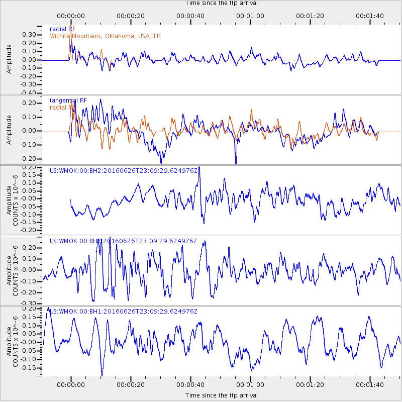
WMOK Wichita Mountains, Oklahoma, USA - Earthquake Result Viewer
*The percent match for this event was below the threshold and hence no stack was calculated.
| Earthquake location: |
Off East Coast Of Honshu, Japan |
| Earthquake latitude/longitude: |
37.0/142.1 |
| Earthquake time(UTC): |
2016/06/26 (178) 22:57:08 GMT |
| Earthquake Depth: |
19 km |
| Earthquake Magnitude: |
5.5 MWR |
| Earthquake Catalog/Contributor: |
NEIC PDE/NEIC COMCAT |
|
| Network: |
US United States National Seismic Network |
| Station: |
WMOK Wichita Mountains, Oklahoma, USA |
| Lat/Lon: |
34.74 N/98.78 W |
| Elevation: |
486 m |
|
| Distance: |
88.8 deg |
| Az: |
46.05 deg |
| Baz: |
315.619 deg |
| Ray Param: |
$rayparam |
*The percent match for this event was below the threshold and hence was not used in the summary stack. |
|
| Radial Match: |
69.22405 % |
| Radial Bump: |
400 |
| Transverse Match: |
40.472187 % |
| Transverse Bump: |
400 |
| SOD ConfigId: |
1634031 |
| Insert Time: |
2016-07-10 23:01:03.585 +0000 |
| GWidth: |
2.5 |
| Max Bumps: |
400 |
| Tol: |
0.001 |
|
Signal To Noise
| Channel | StoN | STA | LTA |
| US:WMOK:00:BHZ:20160626T23:09:29.624976Z | 0.77952045 | 6.328276E-8 | 8.118166E-8 |
| US:WMOK:00:BH1:20160626T23:09:29.624976Z | 1.0789064 | 1.0841865E-7 | 1.0048938E-7 |
| US:WMOK:00:BH2:20160626T23:09:29.624976Z | 1.011978 | 5.4341648E-8 | 5.3698447E-8 |
| Arrivals |
| Ps | |
| PpPs | |
| PsPs/PpSs | |


