You are here: Home > Network List > OH - Ohio Seismic Network Stations List
> Station SSFO Shawnee State Forest Ohio > Earthquake Result Viewer
SSFO Shawnee State Forest Ohio - Earthquake Result Viewer
| Earthquake location: |
Near Coast Of Venezuela |
| Earthquake latitude/longitude: |
10.6/-62.9 |
| Earthquake time(UTC): |
2018/08/22 (234) 13:27:47 GMT |
| Earthquake Depth: |
98 km |
| Earthquake Magnitude: |
5.8 Mww |
| Earthquake Catalog/Contributor: |
NEIC PDE/us |
|
| Network: |
OH Ohio Seismic Network |
| Station: |
SSFO Shawnee State Forest Ohio |
| Lat/Lon: |
38.70 N/83.20 W |
| Elevation: |
365 m |
|
| Distance: |
33.3 deg |
| Az: |
330.443 deg |
| Baz: |
141.698 deg |
| Ray Param: |
0.077975795 |
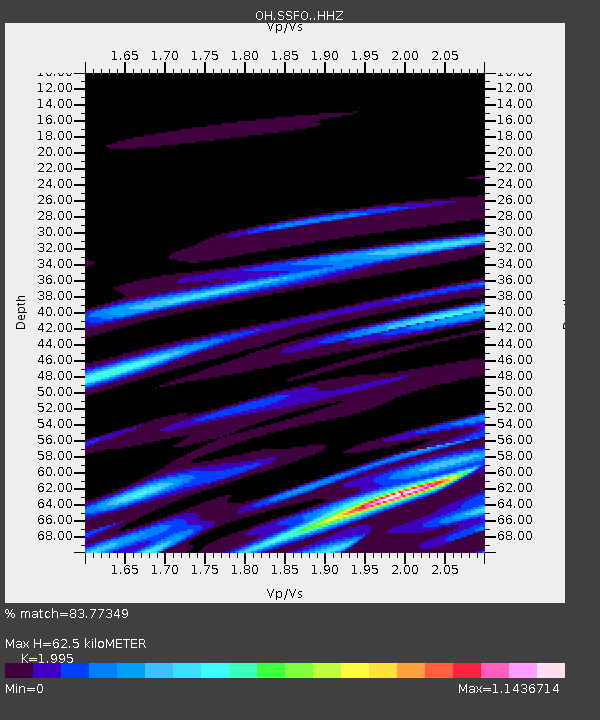
| Estimated Moho Depth: |
62.5 km |
| Estimated Crust Vp/Vs: |
2.00 |
| Assumed Crust Vp: |
6.232 km/s |
| Estimated Crust Vs: |
3.124 km/s |
| Estimated Crust Poisson's Ratio: |
0.33 |
|
| Radial Match: |
83.77349 % |
| Radial Bump: |
400 |
| Transverse Match: |
59.1896 % |
| Transverse Bump: |
400 |
| SOD ConfigId: |
13570011 |
| Insert Time: |
2019-04-30 23:04:38.007 +0000 |
| GWidth: |
2.5 |
| Max Bumps: |
400 |
| Tol: |
0.001 |
|

Signal To Noise
| Channel | StoN | STA | LTA |
| OH:SSFO: :HHZ:20180822T13:33:45.409987Z | 7.6677694 | 1.4149527E-6 | 1.8453251E-7 |
| OH:SSFO: :HHN:20180822T13:33:45.409987Z | 5.4100013 | 8.417413E-7 | 1.5558986E-7 |
| OH:SSFO: :HHE:20180822T13:33:45.409987Z | 2.4231105 | 7.02729E-7 | 2.9001114E-7 |
| Arrivals |
| Ps | 11 SECOND |
| PpPs | 28 SECOND |
| PsPs/PpSs | 39 SECOND |


