You are here: Home > Network List > OK - Oklahoma Seismic Network Stations List
> Station X37A Clayton, Oklahoma, USA > Earthquake Result Viewer
X37A Clayton, Oklahoma, USA - Earthquake Result Viewer
| Earthquake location: |
Near Coast Of Venezuela |
| Earthquake latitude/longitude: |
10.6/-62.9 |
| Earthquake time(UTC): |
2018/08/22 (234) 13:27:47 GMT |
| Earthquake Depth: |
98 km |
| Earthquake Magnitude: |
5.8 Mww |
| Earthquake Catalog/Contributor: |
NEIC PDE/us |
|
| Network: |
OK Oklahoma Seismic Network |
| Station: |
X37A Clayton, Oklahoma, USA |
| Lat/Lon: |
34.59 N/95.37 W |
| Elevation: |
207 m |
|
| Distance: |
38.0 deg |
| Az: |
314.071 deg |
| Baz: |
121.104 deg |
| Ray Param: |
0.075469844 |
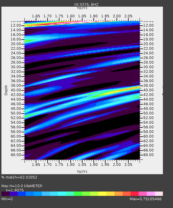
| Estimated Moho Depth: |
10.0 km |
| Estimated Crust Vp/Vs: |
1.91 |
| Assumed Crust Vp: |
6.498 km/s |
| Estimated Crust Vs: |
3.406 km/s |
| Estimated Crust Poisson's Ratio: |
0.31 |
|
| Radial Match: |
82.02852 % |
| Radial Bump: |
400 |
| Transverse Match: |
55.92627 % |
| Transverse Bump: |
400 |
| SOD ConfigId: |
13570011 |
| Insert Time: |
2019-04-30 23:04:45.135 +0000 |
| GWidth: |
2.5 |
| Max Bumps: |
400 |
| Tol: |
0.001 |
|

Signal To Noise
| Channel | StoN | STA | LTA |
| OK:X37A: :BHZ:20180822T13:34:25.449995Z | 5.513211 | 5.540601E-7 | 1.004968E-7 |
| OK:X37A: :BHN:20180822T13:34:25.449995Z | 1.0680068 | 4.4684384E-8 | 4.1839044E-8 |
| OK:X37A: :BHE:20180822T13:34:25.449995Z | 3.6261241 | 2.7656554E-7 | 7.627029E-8 |
| Arrivals |
| Ps | 1.5 SECOND |
| PpPs | 4.2 SECOND |
| PsPs/PpSs | 5.7 SECOND |


