You are here: Home > Network List > TA - USArray Transportable Network (new EarthScope stations) Stations List
> Station 833A Chaparral WMA, Artesia Wells, TX, USA > Earthquake Result Viewer
833A Chaparral WMA, Artesia Wells, TX, USA - Earthquake Result Viewer

| Earthquake location: |
Near Coast Of Venezuela |
| Earthquake latitude/longitude: |
10.6/-62.9 |
| Earthquake time(UTC): |
2018/08/22 (234) 13:27:47 GMT |
| Earthquake Depth: |
98 km |
| Earthquake Magnitude: |
5.8 Mww |
| Earthquake Catalog/Contributor: |
NEIC PDE/us |
|
| Network: |
TA USArray Transportable Network (new EarthScope stations) |
| Station: |
833A Chaparral WMA, Artesia Wells, TX, USA |
| Lat/Lon: |
28.32 N/99.39 W |
| Elevation: |
171 m |
|
| Distance: |
38.4 deg |
| Az: |
302.563 deg |
| Baz: |
109.961 deg |
| Ray Param: |
0.07523224 |
| Estimated Moho Depth: |
32.0 km |
| Estimated Crust Vp/Vs: |
1.81 |
| Assumed Crust Vp: |
6.347 km/s |
| Estimated Crust Vs: |
3.512 km/s |
| Estimated Crust Poisson's Ratio: |
0.28 |
|
| Radial Match: |
85.24384 % |
| Radial Bump: |
400 |
| Transverse Match: |
64.561935 % |
| Transverse Bump: |
400 |
| SOD ConfigId: |
13570011 |
| Insert Time: |
2019-04-30 23:06:16.076 +0000 |
| GWidth: |
2.5 |
| Max Bumps: |
400 |
| Tol: |
0.001 |
|
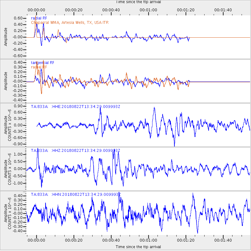
Signal To Noise
| Channel | StoN | STA | LTA |
| TA:833A: :HHZ:20180822T13:34:29.009993Z | 5.120316 | 6.1894997E-7 | 1.2088121E-7 |
| TA:833A: :HHN:20180822T13:34:29.009993Z | 1.3464593 | 1.1621388E-7 | 8.631073E-8 |
| TA:833A: :HHE:20180822T13:34:29.009993Z | 5.1877794 | 3.473094E-7 | 6.69476E-8 |
| Arrivals |
| Ps | 4.4 SECOND |
| PpPs | 13 SECOND |
| PsPs/PpSs | 18 SECOND |


