You are here: Home > Network List > TA - USArray Transportable Network (new EarthScope stations) Stations List
> Station E18K Tukpahlearik Creek, AK, USA > Earthquake Result Viewer
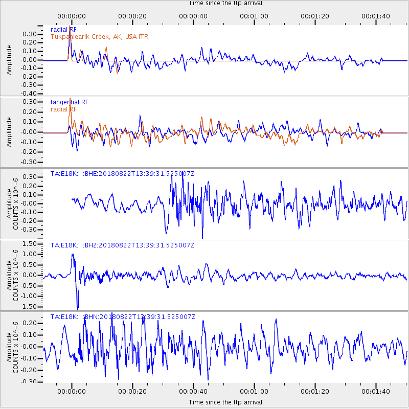
E18K Tukpahlearik Creek, AK, USA - Earthquake Result Viewer
*The percent match for this event was below the threshold and hence no stack was calculated.
| Earthquake location: |
Near Coast Of Venezuela |
| Earthquake latitude/longitude: |
10.6/-62.9 |
| Earthquake time(UTC): |
2018/08/22 (234) 13:27:47 GMT |
| Earthquake Depth: |
98 km |
| Earthquake Magnitude: |
5.8 Mww |
| Earthquake Catalog/Contributor: |
NEIC PDE/us |
|
| Network: |
TA USArray Transportable Network (new EarthScope stations) |
| Station: |
E18K Tukpahlearik Creek, AK, USA |
| Lat/Lon: |
67.42 N/160.60 W |
| Elevation: |
297 m |
|
| Distance: |
83.2 deg |
| Az: |
337.334 deg |
| Baz: |
78.869 deg |
| Ray Param: |
$rayparam |
*The percent match for this event was below the threshold and hence was not used in the summary stack. |
|
| Radial Match: |
76.17446 % |
| Radial Bump: |
400 |
| Transverse Match: |
76.89742 % |
| Transverse Bump: |
400 |
| SOD ConfigId: |
13570011 |
| Insert Time: |
2019-04-30 23:06:36.414 +0000 |
| GWidth: |
2.5 |
| Max Bumps: |
400 |
| Tol: |
0.001 |
|
Signal To Noise
| Channel | StoN | STA | LTA |
| TA:E18K: :BHZ:20180822T13:39:31.525007Z | 8.497324 | 6.4979736E-7 | 7.6470826E-8 |
| TA:E18K: :BHN:20180822T13:39:31.525007Z | 2.1026926 | 1.1299424E-7 | 5.373788E-8 |
| TA:E18K: :BHE:20180822T13:39:31.525007Z | 3.199069 | 1.8630142E-7 | 5.8236132E-8 |
| Arrivals |
| Ps | |
| PpPs | |
| PsPs/PpSs | |


