You are here: Home > Network List > TA - USArray Transportable Network (new EarthScope stations) Stations List
> Station F20K Avaraart Lake, AK, USA > Earthquake Result Viewer
F20K Avaraart Lake, AK, USA - Earthquake Result Viewer
| Earthquake location: |
Near Coast Of Venezuela |
| Earthquake latitude/longitude: |
10.6/-62.9 |
| Earthquake time(UTC): |
2018/08/22 (234) 13:27:47 GMT |
| Earthquake Depth: |
98 km |
| Earthquake Magnitude: |
5.8 Mww |
| Earthquake Catalog/Contributor: |
NEIC PDE/us |
|
| Network: |
TA USArray Transportable Network (new EarthScope stations) |
| Station: |
F20K Avaraart Lake, AK, USA |
| Lat/Lon: |
67.05 N/155.73 W |
| Elevation: |
136 m |
|
| Distance: |
81.4 deg |
| Az: |
336.664 deg |
| Baz: |
83.273 deg |
| Ray Param: |
0.04737616 |
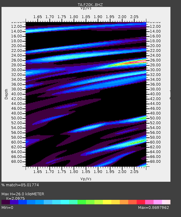
| Estimated Moho Depth: |
26.0 km |
| Estimated Crust Vp/Vs: |
2.10 |
| Assumed Crust Vp: |
6.522 km/s |
| Estimated Crust Vs: |
3.109 km/s |
| Estimated Crust Poisson's Ratio: |
0.35 |
|
| Radial Match: |
85.01774 % |
| Radial Bump: |
400 |
| Transverse Match: |
75.4348 % |
| Transverse Bump: |
400 |
| SOD ConfigId: |
13570011 |
| Insert Time: |
2019-04-30 23:06:47.407 +0000 |
| GWidth: |
2.5 |
| Max Bumps: |
400 |
| Tol: |
0.001 |
|
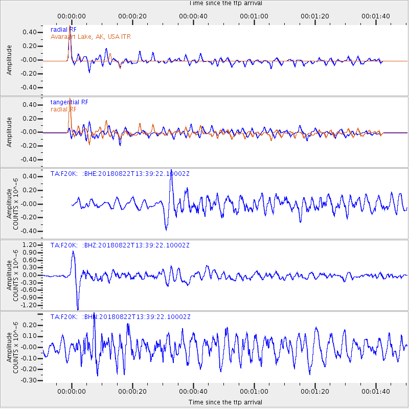
Signal To Noise
| Channel | StoN | STA | LTA |
| TA:F20K: :BHZ:20180822T13:39:22.10002Z | 14.075265 | 5.9120487E-7 | 4.200311E-8 |
| TA:F20K: :BHN:20180822T13:39:22.10002Z | 1.2528583 | 5.865596E-8 | 4.6817714E-8 |
| TA:F20K: :BHE:20180822T13:39:22.10002Z | 4.64513 | 2.2809616E-7 | 4.910436E-8 |
| Arrivals |
| Ps | 4.5 SECOND |
| PpPs | 12 SECOND |
| PsPs/PpSs | 17 SECOND |


