You are here: Home > Network List > TA - USArray Transportable Network (new EarthScope stations) Stations List
> Station L15K Ungalak Mountain, AK, USA > Earthquake Result Viewer
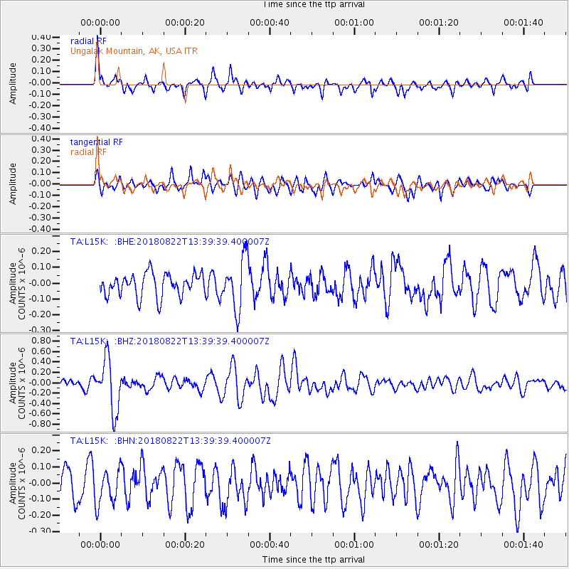
L15K Ungalak Mountain, AK, USA - Earthquake Result Viewer
*The percent match for this event was below the threshold and hence no stack was calculated.
| Earthquake location: |
Near Coast Of Venezuela |
| Earthquake latitude/longitude: |
10.6/-62.9 |
| Earthquake time(UTC): |
2018/08/22 (234) 13:27:47 GMT |
| Earthquake Depth: |
98 km |
| Earthquake Magnitude: |
5.8 Mww |
| Earthquake Catalog/Contributor: |
NEIC PDE/us |
|
| Network: |
TA USArray Transportable Network (new EarthScope stations) |
| Station: |
L15K Ungalak Mountain, AK, USA |
| Lat/Lon: |
61.68 N/161.49 W |
| Elevation: |
219 m |
|
| Distance: |
84.8 deg |
| Az: |
331.737 deg |
| Baz: |
77.488 deg |
| Ray Param: |
$rayparam |
*The percent match for this event was below the threshold and hence was not used in the summary stack. |
|
| Radial Match: |
74.82218 % |
| Radial Bump: |
400 |
| Transverse Match: |
57.29049 % |
| Transverse Bump: |
400 |
| SOD ConfigId: |
13570011 |
| Insert Time: |
2019-04-30 23:07:35.667 +0000 |
| GWidth: |
2.5 |
| Max Bumps: |
400 |
| Tol: |
0.001 |
|
Signal To Noise
| Channel | StoN | STA | LTA |
| TA:L15K: :BHZ:20180822T13:39:39.400007Z | 7.8223653 | 5.145412E-7 | 6.577822E-8 |
| TA:L15K: :BHN:20180822T13:39:39.400007Z | 1.2835965 | 1.0828267E-7 | 8.43588E-8 |
| TA:L15K: :BHE:20180822T13:39:39.400007Z | 2.3855233 | 1.7335975E-7 | 7.267158E-8 |
| Arrivals |
| Ps | |
| PpPs | |
| PsPs/PpSs | |


