You are here: Home > Network List > TA - USArray Transportable Network (new EarthScope stations) Stations List
> Station O17K Koliganek, Bristol Bay, AK, USA > Earthquake Result Viewer
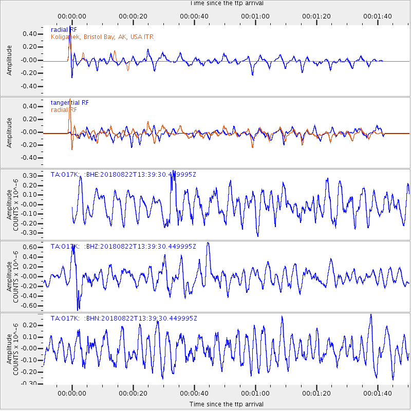
O17K Koliganek, Bristol Bay, AK, USA - Earthquake Result Viewer
*The percent match for this event was below the threshold and hence no stack was calculated.
| Earthquake location: |
Near Coast Of Venezuela |
| Earthquake latitude/longitude: |
10.6/-62.9 |
| Earthquake time(UTC): |
2018/08/22 (234) 13:27:47 GMT |
| Earthquake Depth: |
98 km |
| Earthquake Magnitude: |
5.8 Mww |
| Earthquake Catalog/Contributor: |
NEIC PDE/us |
|
| Network: |
TA USArray Transportable Network (new EarthScope stations) |
| Station: |
O17K Koliganek, Bristol Bay, AK, USA |
| Lat/Lon: |
59.77 N/157.09 W |
| Elevation: |
156 m |
|
| Distance: |
83.0 deg |
| Az: |
329.446 deg |
| Baz: |
81.071 deg |
| Ray Param: |
$rayparam |
*The percent match for this event was below the threshold and hence was not used in the summary stack. |
|
| Radial Match: |
52.606693 % |
| Radial Bump: |
362 |
| Transverse Match: |
63.272663 % |
| Transverse Bump: |
331 |
| SOD ConfigId: |
13570011 |
| Insert Time: |
2019-04-30 23:08:06.281 +0000 |
| GWidth: |
2.5 |
| Max Bumps: |
400 |
| Tol: |
0.001 |
|
Signal To Noise
| Channel | StoN | STA | LTA |
| TA:O17K: :BHZ:20180822T13:39:30.449995Z | 3.1234016 | 3.7551064E-7 | 1.202249E-7 |
| TA:O17K: :BHN:20180822T13:39:30.449995Z | 0.84804916 | 9.4810574E-8 | 1.1179844E-7 |
| TA:O17K: :BHE:20180822T13:39:30.449995Z | 1.703211 | 2.0768873E-7 | 1.2193952E-7 |
| Arrivals |
| Ps | |
| PpPs | |
| PsPs/PpSs | |


