You are here: Home > Network List > IU - Global Seismograph Network (GSN - IRIS/USGS) Stations List
> Station XMAS Kiritimati Island, Republic of Kiribati > Earthquake Result Viewer
XMAS Kiritimati Island, Republic of Kiribati - Earthquake Result Viewer
| Earthquake location: |
Fiji Islands |
| Earthquake latitude/longitude: |
-17.2/178.3 |
| Earthquake time(UTC): |
2009/11/09 (313) 10:44:54 GMT |
| Earthquake Depth: |
591 km |
| Earthquake Magnitude: |
6.6 MB, 7.3 MW, 7.2 MW |
| Earthquake Catalog/Contributor: |
WHDF/NEIC |
|
| Network: |
IU Global Seismograph Network (GSN - IRIS/USGS) |
| Station: |
XMAS Kiritimati Island, Republic of Kiribati |
| Lat/Lon: |
2.04 N/157.45 W |
| Elevation: |
20 m |
|
| Distance: |
30.6 deg |
| Az: |
53.598 deg |
| Baz: |
230.324 deg |
| Ray Param: |
0.07673797 |
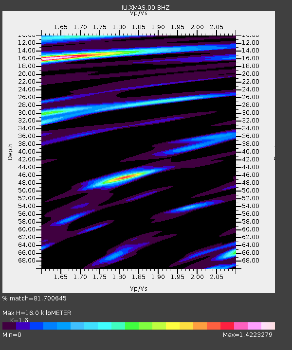
| Estimated Moho Depth: |
16.0 km |
| Estimated Crust Vp/Vs: |
1.60 |
| Assumed Crust Vp: |
4.802 km/s |
| Estimated Crust Vs: |
3.001 km/s |
| Estimated Crust Poisson's Ratio: |
0.18 |
|
| Radial Match: |
81.700645 % |
| Radial Bump: |
400 |
| Transverse Match: |
81.46646 % |
| Transverse Bump: |
400 |
| SOD ConfigId: |
1 |
| Insert Time: |
2010-02-19 01:09:00.376 +0000 |
| GWidth: |
2.5 |
| Max Bumps: |
400 |
| Tol: |
0.001 |
|

Signal To Noise
| Channel | StoN | STA | LTA |
| IU:XMAS:00:BHZ:20091109T10:49:51.83601Z | 10.417625 | 2.1502543E-5 | 2.0640543E-6 |
| IU:XMAS:00:BHN:20091109T10:49:51.83601Z | 8.142976 | 8.094963E-6 | 9.941039E-7 |
| IU:XMAS:00:BHE:20091109T10:49:51.83601Z | 4.0961895 | 7.515701E-6 | 1.8348029E-6 |
| Arrivals |
| Ps | 2.1 SECOND |
| PpPs | 8.3 SECOND |
| PsPs/PpSs | 10 SECOND |


