You are here: Home > Network List > TA - USArray Transportable Network (new EarthScope stations) Stations List
> Station D25K Kavik River, AK, USA > Earthquake Result Viewer
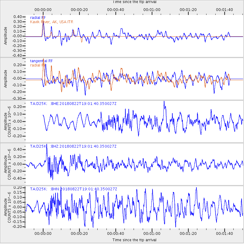
D25K Kavik River, AK, USA - Earthquake Result Viewer
*The percent match for this event was below the threshold and hence no stack was calculated.
| Earthquake location: |
Solomon Islands |
| Earthquake latitude/longitude: |
-7.0/155.7 |
| Earthquake time(UTC): |
2018/08/22 (234) 18:49:36 GMT |
| Earthquake Depth: |
34 km |
| Earthquake Magnitude: |
5.8 Mww |
| Earthquake Catalog/Contributor: |
NEIC PDE/us |
|
| Network: |
TA USArray Transportable Network (new EarthScope stations) |
| Station: |
D25K Kavik River, AK, USA |
| Lat/Lon: |
69.32 N/146.38 W |
| Elevation: |
770 m |
|
| Distance: |
85.7 deg |
| Az: |
17.562 deg |
| Baz: |
237.495 deg |
| Ray Param: |
$rayparam |
*The percent match for this event was below the threshold and hence was not used in the summary stack. |
|
| Radial Match: |
61.678276 % |
| Radial Bump: |
400 |
| Transverse Match: |
68.68776 % |
| Transverse Bump: |
400 |
| SOD ConfigId: |
13570011 |
| Insert Time: |
2019-04-30 23:15:51.604 +0000 |
| GWidth: |
2.5 |
| Max Bumps: |
400 |
| Tol: |
0.001 |
|
Signal To Noise
| Channel | StoN | STA | LTA |
| TA:D25K: :BHZ:20180822T19:01:40.350027Z | 3.1376889 | 1.9736792E-7 | 6.290232E-8 |
| TA:D25K: :BHN:20180822T19:01:40.350027Z | 1.2520956 | 5.8091327E-8 | 4.639528E-8 |
| TA:D25K: :BHE:20180822T19:01:40.350027Z | 1.0191684 | 6.490748E-8 | 6.368671E-8 |
| Arrivals |
| Ps | |
| PpPs | |
| PsPs/PpSs | |


